Title:
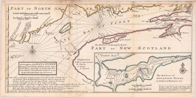
“A Description of the Bay of Fundy Shewing ye Coast, Islands, Harbours, Creeks, Coves, Rocks, Sholes, Soundings & Anchorings &c. Observed by Nat. Blackmore in ye Years 1711 and 1712...”
Map Maker:
Herman Moll
This fascinating map covers part of the coast of M... (full text available to subscribers)
| Item Detail |
| |
| |
MapMaker: |
Herman Moll
|
|
| |
| |
Subject: |
Bay of Fundy |
|
| |
Period/Size: |
1745 / 8.3" x 17.3" (21.1 x 44.0 cm)
|
|
| |
Color: |
Colored
|
|
| |
Condition: |
(B+) A crisp impression issued folding a sheet with a fleur-de-lis watermark. There is light scattered foxing and soiling and two tiny fold separations at top. (condition help) |
|
| |
Source: |
Atlas Minor... |
|
| |
References: |
Shirley (BL Atlases) T.MOLL-9a #50; Kershaw #763; Phillips (A) #574-54. |
|
| |
|
|
| Sales Information |
| |
| |
Price: |
|
|
| |
| |
Offered by: |
Old World Auctions |
|
| |
Catalog: |
Auction No. 188 - Antique Maps, Charts, Atlases & Globes (9558) |
|
| |
Lot/Item #: |
114 |
|
| |
| |
Date: |
04/2022
|
|
| |
| |
|
Antique Maps - Valuation and Pricing, Descriptions, Resources |
|
Home |
Information |
Search |
Register |
Contact Us |
Site Map
Americana Exchange, Inc. © 1999 - 2024 Americana Exchange, Inc.. All rights reserved.
OldMaps.com, the OldMaps.com logo and
AMPR are service marks or registered service marks of Americana Exchange, Inc..
|