Title:
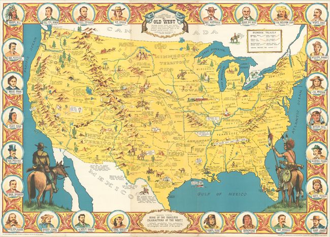
“Sheriff Danny Arnold's Pictorial Map of the Old West Showing Pioneer Trails and Battles, Indian's Territories, Stagecoach Lines, Military Forts, Historical Data of the Frontier Period Around 1840”
This pictorial map of the United States shows the ... (full text available to subscribers)
| Item Detail |
| |
| |
MapMaker: |
(none given)
|
|
| |
| |
Subject: |
United States |
|
| |
Period/Size: |
1960 / 24.4" x 34.4" (62.0 x 87.4 cm)
|
|
| |
Color: |
Colored
|
|
| |
Condition: |
(A) Overall clean and bright, issued folding with a few tiny splits at fold intersections, some light wear along the folds, and minor foxing at bottom center. (condition help) |
|
| |
Source: |
|
|
| |
References: |
|
|
| |
|
|
| Sales Information |
| |
| |
Price: |
|
|
| |
| |
Offered by: |
Old World Auctions |
|
| |
Catalog: |
Auction No. 188 - Antique Maps, Charts, Atlases & Globes (9558) |
|
| |
Lot/Item #: |
129 |
|
| |
| |
Date: |
04/2022
|
|
| |
| |
|
Antique Maps - Valuation and Pricing, Descriptions, Resources |
|
Home |
Information |
Search |
Register |
Contact Us |
Site Map
Americana Exchange, Inc. © 1999 - 2024 Americana Exchange, Inc.. All rights reserved.
OldMaps.com, the OldMaps.com logo and
AMPR are service marks or registered service marks of Americana Exchange, Inc..
|