Title:
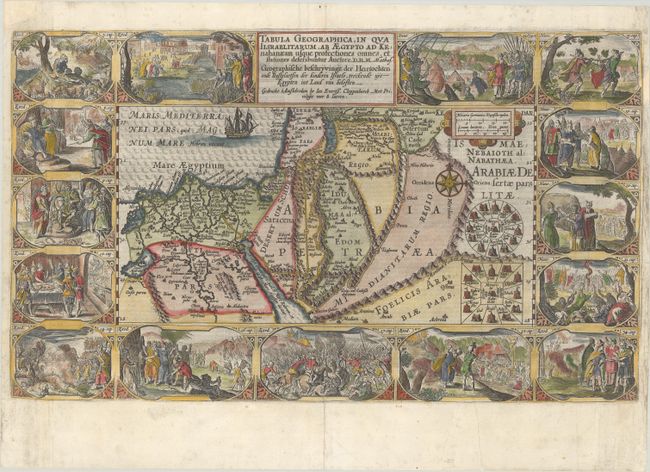
“Tabula Geographica, in qua Iisraelitarum, ab Aegypto ad Kenahanaeam Usque Profectiones Omnes... / Geographische Beschryvinge der Heirtochten ende Rustplaetsen der Kinderen Israels, Treckende uyt Egypten in Land van Belosten...”
Map Maker:
Plancius/Cloppenburg
This extremely decorative Bible map illustrates th... (full text available to subscribers)
| Item Detail |
| |
| |
MapMaker: |
Plancius/Cloppenburg
|
|
| |
| |
Subject: |
Holy Land |
|
| |
Period/Size: |
1643 / 11.5" x 19.4" (29.3 x 49.3 cm)
|
|
| |
Color: |
Colored
|
|
| |
Condition: |
(B+) A sharp impression on a bright sheet, issued folding with light soiling along the sides of the sheet and narrow side margins, as issued. There are professional repairs to a centerfold separation at bottom, a chip at top left, and a chip and tear wit (condition help) |
|
| |
Source: |
|
|
| |
References: |
Laor #566; Poortman & Augusteijn #76. |
|
| |
|
|
| Sales Information |
| |
| |
Price: |
|
|
| |
| |
Offered by: |
Old World Auctions |
|
| |
Catalog: |
Auction No. 188 - Antique Maps, Charts, Atlases & Globes (9558) |
|
| |
Lot/Item #: |
607 |
|
| |
| |
Date: |
04/2022
|
|
| |
| |
|
Antique Maps - Valuation and Pricing, Descriptions, Resources |
|
Home |
Information |
Search |
Register |
Contact Us |
Site Map
Americana Exchange, Inc. © 1999 - 2024 Americana Exchange, Inc.. All rights reserved.
OldMaps.com, the OldMaps.com logo and
AMPR are service marks or registered service marks of Americana Exchange, Inc..
|