Title:
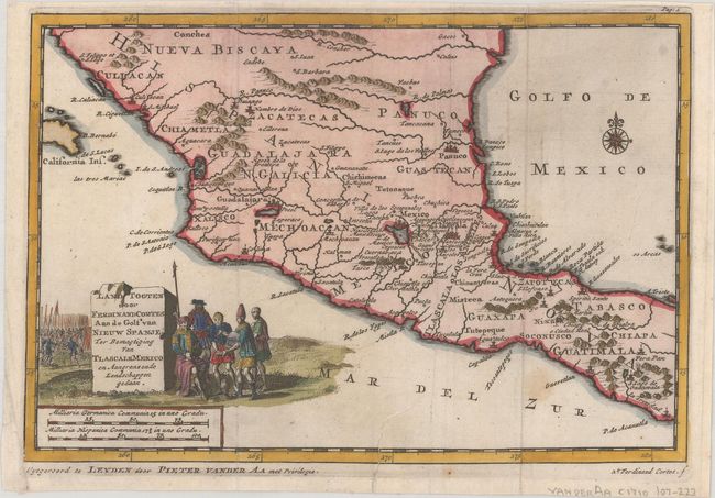
“Land Togten door Ferdinand Cortes aan de Golf van Nieuw Spanje, ter Bemagtiging van Tlascale Mexico en Aangrenzende Landschappen Gedaan”
Map Maker:
Pieter van der Aa
This finely engraved map of central Mexico was des... (full text available to subscribers)
| Item Detail |
| |
| |
MapMaker: |
Pieter van der Aa
|
|
| |
| |
Subject: |
Mexico |
|
| |
Period/Size: |
1710 / 5.9" x 8.7" (15.0 x 22.1 cm)
|
|
| |
Color: |
Colored
|
|
| |
Condition: |
(B+) A dark impression, issued folding with a couple of faint spots and a tear entering map 1" at bottom that has been closed with archival tape. (condition help) |
|
| |
Source: |
Naauwkeurige Versameling der Gedenk-Waardigste Zee en Landreysen… |
|
| |
References: |
cf. Shirley (BL Atlases) G.AA-1a #40. |
|
| |
|
|
| Sales Information |
| |
| |
Price: |
|
|
| |
| |
Offered by: |
Old World Auctions |
|
| |
Catalog: |
Auction No. 189 - Antique Maps, Charts, Atlases & Globes (9559) |
|
| |
Lot/Item #: |
280 |
|
| |
| |
Date: |
09/2022
|
|
| |
| |
|
Antique Maps - Valuation and Pricing, Descriptions, Resources |
|
Home |
Information |
Search |
Register |
Contact Us |
Site Map
Americana Exchange, Inc. © 1999 - 2024 Americana Exchange, Inc.. All rights reserved.
OldMaps.com, the OldMaps.com logo and
AMPR are service marks or registered service marks of Americana Exchange, Inc..
|