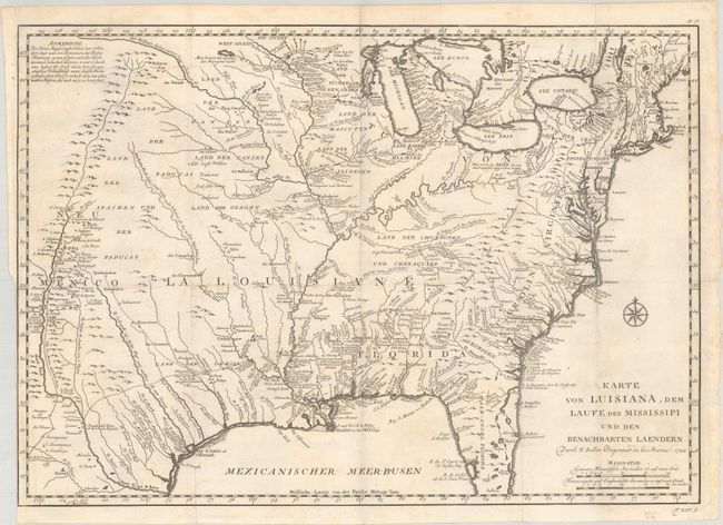
Title:
“Karte von Luisiana, dem Laufe des Mississipi und den Benachbarten Laendern”
Map Maker:
Jacques Nicolas Bellin
This is a scarce German issue of Bellin's map of L... (full text available to subscribers)
| Item Detail |
| |
| |
MapMaker: |
Jacques Nicolas Bellin
|
|
| |
| |
Subject: |
Colonial Eastern United States |
|
| |
Period/Size: |
1744 / 15.6" x 22.2" (39.7 x 56.4 cm)
|
|
| |
Color: |
Black & White
|
|
| |
Condition: |
(A) A crisp impression, issued folding on a watermarked sheet with a hint of toning. (condition help) |
|
| |
Source: |
Allegmeine Historie der Reisen zu Wasser und zu Lande |
|
| |
References: |
Brown (Ohio) pp. 69-70; cf. McCorkle #744-1; cf. Tooley (MCC-96) #703. |
|
| |
|
|
| Sales Information |
| |
| |
Price: |
|
|
| |
| |
Offered by: |
Old World Auctions |
|
| |
Catalog: |
Auction No. 189 - Antique Maps, Charts, Atlases & Globes (9559) |
|
| |
Lot/Item #: |
141 |
|
| |
| |
Date: |
09/2022
|
|
| |
| |
|
Antique Maps - Valuation and Pricing, Descriptions, Resources |
|
Home |
Information |
Search |
Register |
Contact Us |
Site Map
Americana Exchange, Inc. © 1999 - 2024 Americana Exchange, Inc.. All rights reserved.
OldMaps.com, the OldMaps.com logo and
AMPR are service marks or registered service marks of Americana Exchange, Inc..
|