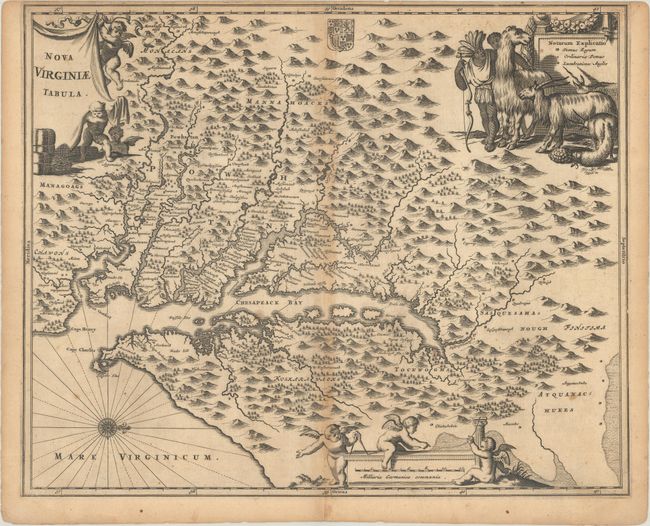
Title:
“Nova Virginiae Tabula”
Map Maker:
Arnoldus Montanus
This is a very decorative, carefully made map base... (full text available to subscribers)
| Item Detail |
| |
| |
MapMaker: |
Arnoldus Montanus
|
|
| |
| |
Subject: |
Colonial Mid-Atlantic United States |
|
| |
Period/Size: |
1671 / 11.5" x 14.1" (29.3 x 35.9 cm)
|
|
| |
Color: |
Black & White
|
|
| |
Condition: |
(B) A dark impression on paper with a jester watermark. There is minor foxing and light toning that is more prominent along the centerfold. Narrow top margin. (condition help) |
|
| |
Source: |
De Nieuwe en Onbekende Weereld |
|
| |
References: |
Burden #412; Goss (NA) #38; Tooley (Amer) p.168-9, plt. 76. |
|
| |
|
|
| Sales Information |
| |
| |
Price: |
|
|
| |
| |
Offered by: |
Old World Auctions |
|
| |
Catalog: |
Auction No. 189 - Antique Maps, Charts, Atlases & Globes (9559) |
|
| |
Lot/Item #: |
162 |
|
| |
| |
Date: |
09/2022
|
|
| |
| |
|
Antique Maps - Valuation and Pricing, Descriptions, Resources |
|
Home |
Information |
Search |
Register |
Contact Us |
Site Map
Americana Exchange, Inc. © 1999 - 2024 Americana Exchange, Inc.. All rights reserved.
OldMaps.com, the OldMaps.com logo and
AMPR are service marks or registered service marks of Americana Exchange, Inc..
|