Title:
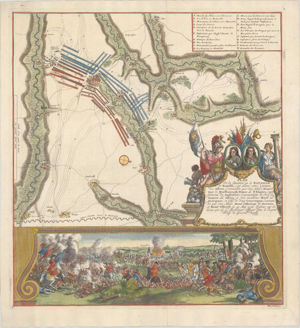
“Plan de la Situation ou la Bataille de Ramillis, cest donne Entre l Armee des Alliees, Commandre par son Altesse Monsr. le Duc de Marlborough, Prince de St. Empire...”
This scarce and striking sheet depicting the Battl... (full text available to subscribers)
| Item Detail |
| |
| |
MapMaker: |
(none given)
|
|
| |
| |
Subject: |
Ramillies, Belgium |
|
| |
Period/Size: |
1729 / 18.5" x 17.1" (47.0 x 43.5 cm)
|
|
| |
Color: |
Colored
|
|
| |
Condition: |
(A) On a sheet with a "H" watermark and a bit of printer's ink residue. (condition help) |
|
| |
Source: |
|
|
| |
References: |
|
|
| |
|
|
| Sales Information |
| |
| |
Price: |
|
|
| |
| |
Offered by: |
Old World Auctions |
|
| |
Catalog: |
Auction No. 189 - Antique Maps, Charts, Atlases & Globes (9559) |
|
| |
Lot/Item #: |
426 |
|
| |
| |
Date: |
09/2022
|
|
| |
| |
|
Antique Maps - Valuation and Pricing, Descriptions, Resources |
|
Home |
Information |
Search |
Register |
Contact Us |
Site Map
Americana Exchange, Inc. © 1999 - 2024 Americana Exchange, Inc.. All rights reserved.
OldMaps.com, the OldMaps.com logo and
AMPR are service marks or registered service marks of Americana Exchange, Inc..
|