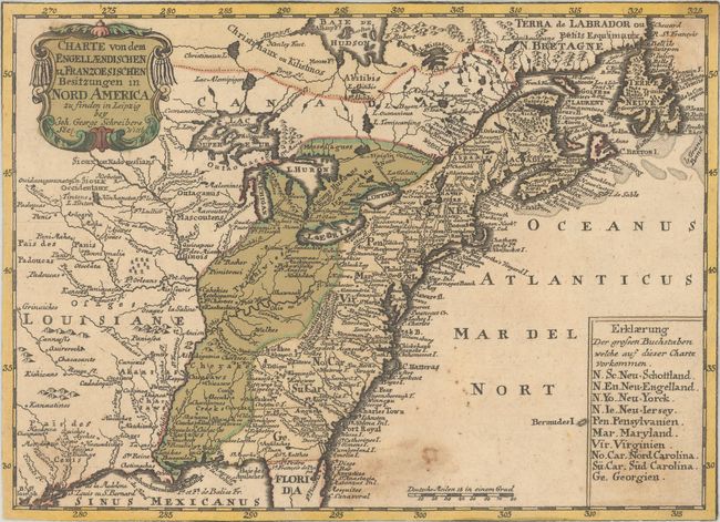
Title:
“Charte von dem Engellaendischen u Franzoesischen Besitzungen in Nord America...”
Map Maker:
Johann Georg Schreiber
This boldly engraved map details the British and F... (full text available to subscribers)
| Item Detail |
| |
| |
MapMaker: |
Johann Georg Schreiber
|
|
| |
| |
Subject: |
Colonial Eastern United States & Canada |
|
| |
Period/Size: |
1753 / 6.9" x 9.5" (17.6 x 24.2 cm)
|
|
| |
Color: |
Colored
|
|
| |
Condition: |
(B) Trimmed to the neatline all around with some light staining that is more prominent at bottom. (condition help) |
|
| |
Source: |
Atlas Selectus |
|
| |
References: |
|
|
| |
|
|
| Sales Information |
| |
| |
Price: |
|
|
| |
| |
Offered by: |
Old World Auctions |
|
| |
Catalog: |
Auction No. 189 - Antique Maps, Charts, Atlases & Globes (9559) |
|
| |
Lot/Item #: |
117 |
|
| |
| |
Date: |
09/2022
|
|
| |
| |
|
Antique Maps - Valuation and Pricing, Descriptions, Resources |
|
Home |
Information |
Search |
Register |
Contact Us |
Site Map
Americana Exchange, Inc. © 1999 - 2024 Americana Exchange, Inc.. All rights reserved.
OldMaps.com, the OldMaps.com logo and
AMPR are service marks or registered service marks of Americana Exchange, Inc..
|