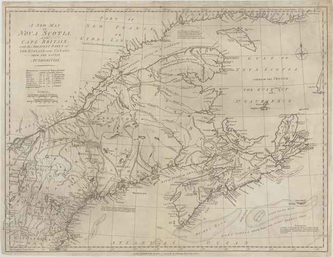
Title:
“A New Map of Nova Scotia, and Cape Britain, with the Adjacent Parts of New England and Canada, from the Latest Authorities”
Map Maker:
John Murray
This map appears to be based upon Thomas Jeffreys'... (full text available to subscribers)
| Item Detail |
| |
| |
MapMaker: |
John Murray
|
|
| |
| |
Subject: |
Northeastern United States & Canada |
|
| |
Period/Size: |
1785 / 18.0" x 23.9" (45.8 x 60.7 cm)
|
|
| |
Color: |
Black & White
|
|
| |
Condition: |
(B+) Issued folding and now flat with professional repairs to a few small fold separations and edge tears. There is some light surface soiling. (condition help) |
|
| |
Source: |
Political Magazine |
|
| |
References: |
Jolly #POL-91; Sellers & Van Ee #188. |
|
| |
|
|
| Sales Information |
| |
| |
Price: |
|
|
| |
| |
Offered by: |
Old World Auctions |
|
| |
Catalog: |
Auction No. 189 - Antique Maps, Charts, Atlases & Globes (9559) |
|
| |
Lot/Item #: |
126 |
|
| |
| |
Date: |
09/2022
|
|
| |
| |
|
Antique Maps - Valuation and Pricing, Descriptions, Resources |
|
Home |
Information |
Search |
Register |
Contact Us |
Site Map
Americana Exchange, Inc. © 1999 - 2024 Americana Exchange, Inc.. All rights reserved.
OldMaps.com, the OldMaps.com logo and
AMPR are service marks or registered service marks of Americana Exchange, Inc..
|