Title:
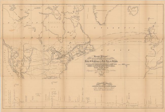
“Mercators Projection. With the Great Circle (Shortest Sailing) or Air Lines, Illustrating the Directness & Capacity of the River St. Lawrence from Lake Erie to the Atlantic...”
Map Maker:
Thomas C. Keefer
This fascinating persuasive map extends from Weste... (full text available to subscribers)
| Item Detail |
| |
| |
MapMaker: |
Thomas C. Keefer
|
|
| |
| |
Subject: |
Canada & United States, Atlantic Ocean |
|
| |
Period/Size: |
1855 / 22.5" x 34.8" (57.2 x 88.4 cm)
|
|
| |
Color: |
Black & White
|
|
| |
Condition: |
(B+) Issued folding with a hint of pleasant light toning. There is minor foxing, faint offsetting, and a few tiny splits at the fold junctions. (condition help) |
|
| |
Source: |
|
|
| |
References: |
|
|
| |
|
|
| Sales Information |
| |
| |
Price: |
|
|
| |
| |
Offered by: |
Old World Auctions |
|
| |
Catalog: |
Auction No. 189 - Antique Maps, Charts, Atlases & Globes (9559) |
|
| |
Lot/Item #: |
112 |
|
| |
| |
Date: |
09/2022
|
|
| |
| |
|
Antique Maps - Valuation and Pricing, Descriptions, Resources |
|
Home |
Information |
Search |
Register |
Contact Us |
Site Map
Americana Exchange, Inc. © 1999 - 2024 Americana Exchange, Inc.. All rights reserved.
OldMaps.com, the OldMaps.com logo and
AMPR are service marks or registered service marks of Americana Exchange, Inc..
|