Title:
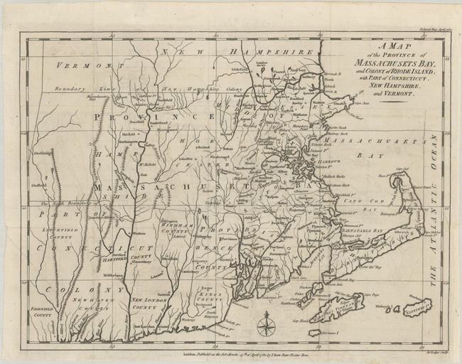
“A Map of the Province of Massachusets Bay, and Colony of Rhode Island, with Part of Connecticut, New Hampshire, and Vermont”
Map Maker:
John Lodge
This rare map of colonial New England was p... (full text available to subscribers)
| Item Detail |
| |
| |
MapMaker: |
John Lodge
|
|
| |
| |
Subject: |
Colonial New England United States |
|
| |
Period/Size: |
1782 / 10.9" x 14.6" (27.7 x 37.1 cm)
|
|
| |
Color: |
Black & White
|
|
| |
Condition: |
(A) A crisp impression issued folding, now flat, on watermarked paper with minor offsetting. A 1.5" binding tear at right has been professionally repaired on verso. (condition help) |
|
| |
Source: |
Political Magazine |
|
| |
References: |
Jolly #POL-50; McCorkle #782.11. |
|
| |
|
|
| Sales Information |
| |
| |
Price: |
|
|
| |
| |
Offered by: |
Old World Auctions |
|
| |
Catalog: |
Auction No. 189 - Antique Maps, Charts, Atlases & Globes (9559) |
|
| |
Lot/Item #: |
158 |
|
| |
| |
Date: |
09/2022
|
|
| |
| |
|
Antique Maps - Valuation and Pricing, Descriptions, Resources |
|
Home |
Information |
Search |
Register |
Contact Us |
Site Map
Americana Exchange, Inc. © 1999 - 2024 Americana Exchange, Inc.. All rights reserved.
OldMaps.com, the OldMaps.com logo and
AMPR are service marks or registered service marks of Americana Exchange, Inc..
|