Title:
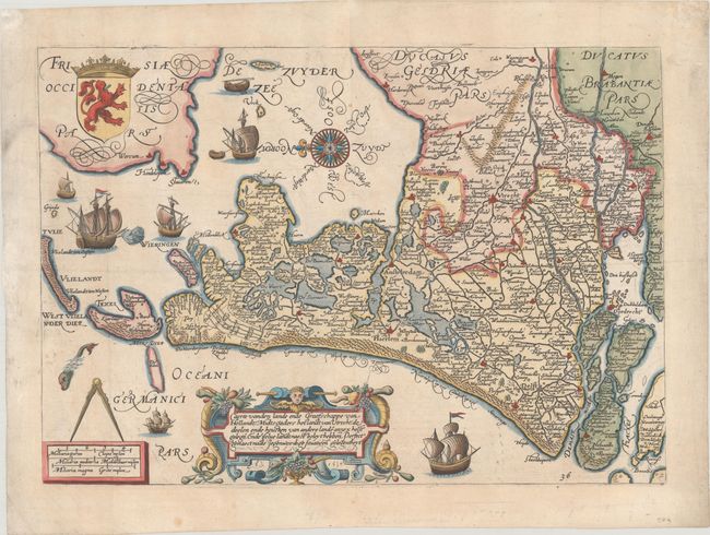
“Caerte vanden Lande ende Graefschappe van Hollandt, Midtsgaders het Landt van Utrecht...”
Map Maker:
Jan Pieterszoon Saenredam
This exquisite map of Holland was the first cartog... (full text available to subscribers)
| Item Detail |
| |
| |
MapMaker: |
Jan Pieterszoon Saenredam
|
|
| |
| |
Subject: |
Netherlands |
|
| |
Period/Size: |
1589 / 10.2" x 14.5" (25.9 x 36.9 cm)
|
|
| |
Color: |
Colored
|
|
| |
Condition: |
(A) A crisp impression on watermarked paper with a few small spots and minor archival repairs in the margins. (condition help) |
|
| |
Source: |
Omnium Belgii, sive Inferioris Germaniae Regionum Descriptio... |
|
| |
References: |
Shirley (BL Atlases) G.GUIC-3b. |
|
| |
|
|
| Sales Information |
| |
| |
Price: |
|
|
| |
| |
Offered by: |
Old World Auctions |
|
| |
Catalog: |
Auction No. 189 - Antique Maps, Charts, Atlases & Globes (9559) |
|
| |
Lot/Item #: |
415 |
|
| |
| |
Date: |
09/2022
|
|
| |
| |
|
Antique Maps - Valuation and Pricing, Descriptions, Resources |
|
Home |
Information |
Search |
Register |
Contact Us |
Site Map
Americana Exchange, Inc. © 1999 - 2024 Americana Exchange, Inc.. All rights reserved.
OldMaps.com, the OldMaps.com logo and
AMPR are service marks or registered service marks of Americana Exchange, Inc..
|