Rister or Sign In to see pricing information


Title:

Lille Insula Ryssele

Map Maker:

Braun & Hogenberg

Lille Insula Ryssele

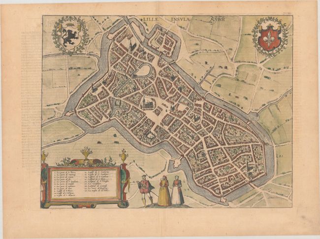
A lovely bird's-eye plan of Lille based on the wor... (full text available to subscribers)
Item Detail
 
  MapMaker:  

Braun & Hogenberg


  Subject:  Lille, France  
  Period/Size:  1582 / 13.0" x 16.9"  (33.1 x 43.0 cm)  
  Color:  Colored  
  Condition:  (A) A nice impression on a watermarked sheet with minor toning. (condition help)  
  Source:  Civitates Orbis Terrarum, Vol. III  
  References:  Fussel, p. 221; Van der Krogt (Vol. IV) #2344.  
 
 
Sales Information
 
  Price: 

Please register your email to view records, or sign in with email address to see records


  Offered by:  Old World Auctions  
  Catalog:  Auction No. 189 - Antique Maps, Charts, Atlases & Globes (9559)  
  Lot/Item #:  451  
 
  Date:  09/2022  


Antique Maps - Valuation and Pricing, Descriptions, Resources


Home | Information | Search | Register | Contact Us | Site Map

Americana Exchange, Inc. © 1999 - 2024 Americana Exchange, Inc.. All rights reserved. OldMaps.com, the OldMaps.com logo and
AMPR are service marks or registered service marks of Americana Exchange, Inc..