Title:
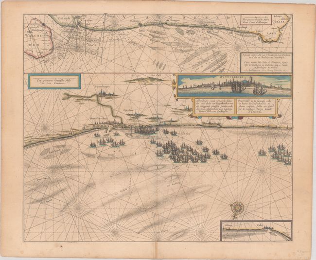
“Afbeeldinghe vande Vermaerde Seehaven ende Stadt van Duynkercken met der Omliggende Plaetsen Sanden ende Droochten… / Pourtraict de la Fameuse Ville et Havre de Duynckerke et Places Voisines...”
Map Maker:
Henricus Hondius
This impressive and uncommon sea chart depicts the... (full text available to subscribers)
| Item Detail |
| |
| |
MapMaker: |
Henricus Hondius
|
|
| |
| |
Subject: |
Northern France |
|
| |
Period/Size: |
1631 / 17.2" x 20.3" (43.7 x 51.6 cm)
|
|
| |
Color: |
Colored
|
|
| |
Condition: |
(B+) A nice impression with contemporary color on a slightly toned sheet. There are a few light spots and a centerfold separation in the bottom margin that has been repaired on recto. (condition help) |
|
| |
Source: |
|
|
| |
References: |
Van der Krogt (Vol. I) #3295:1. |
|
| |
|
|
| Sales Information |
| |
| |
Price: |
|
|
| |
| |
Offered by: |
Old World Auctions |
|
| |
Catalog: |
Auction No. 191 - Antique Maps, Charts, Atlases & Globes (9561) |
|
| |
Lot/Item #: |
524 |
|
| |
| |
Date: |
02/2023
|
|
| |
| |
|
Antique Maps - Valuation and Pricing, Descriptions, Resources |
|
Home |
Information |
Search |
Register |
Contact Us |
Site Map
Americana Exchange, Inc. © 1999 - 2024 Americana Exchange, Inc.. All rights reserved.
OldMaps.com, the OldMaps.com logo and
AMPR are service marks or registered service marks of Americana Exchange, Inc..
|