Title:
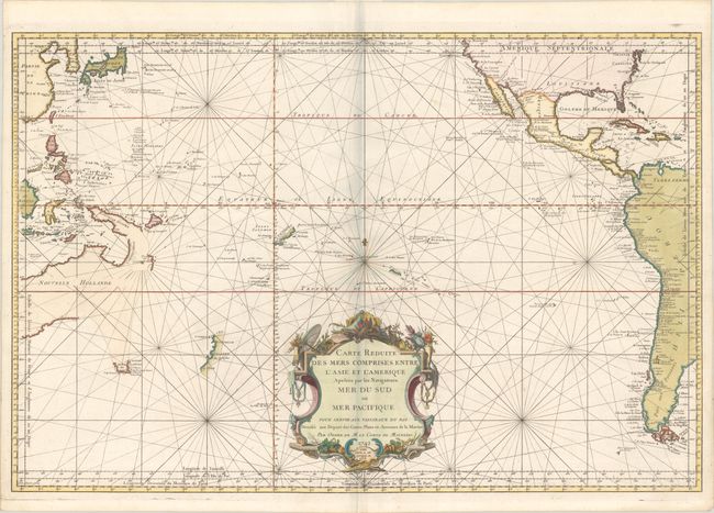
“Carte Reduite des Mers Comprises Entre l'Asie et l'Amerique Apelees par les Navigateurs Mer du Sud ou Mer Pacifique...”
Map Maker:
Jacques Nicolas Bellin
First published by Bellin in 1742, this chart has ... (full text available to subscribers)
| Item Detail |
| |
| |
MapMaker: |
Jacques Nicolas Bellin
|
|
| |
| |
Subject: |
Pacific Ocean |
|
| |
Period/Size: |
1756 / 22.3" x 33.4" (56.7 x 84.9 cm)
|
|
| |
Color: |
Colored
|
|
| |
Condition: |
(A) A dark impression on a clean bright sheet of watermarked paper. (condition help) |
|
| |
Source: |
|
|
| |
References: |
Tooley (Australia) p. 23, #153. |
|
| |
|
|
| Sales Information |
| |
| |
Price: |
|
|
| |
| |
Offered by: |
Old World Auctions |
|
| |
Catalog: |
Auction No. 191 - Antique Maps, Charts, Atlases & Globes (9561) |
|
| |
Lot/Item #: |
764 |
|
| |
| |
Date: |
02/2023
|
|
| |
| |
|
Antique Maps - Valuation and Pricing, Descriptions, Resources |
|
Home |
Information |
Search |
Register |
Contact Us |
Site Map
Americana Exchange, Inc. © 1999 - 2024 Americana Exchange, Inc.. All rights reserved.
OldMaps.com, the OldMaps.com logo and
AMPR are service marks or registered service marks of Americana Exchange, Inc..
|