Title:
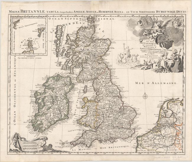
“Les Isles Britanniques qui Contiennent les Royaumes d'Angleterre, Escosse, et Irlande Distingues en Leurs Principales Provinces...”
Map Maker:
Jaillot/Otten
This is the Ottens edition of Jaillot's fine map o... (full text available to subscribers)
| Item Detail |
| |
| |
MapMaker: |
Jaillot/Otten
|
|
| |
| |
Subject: |
Britain |
|
| |
Period/Size: |
1725 / 18.7" x 23.5" (47.5 x 59.7 cm)
|
|
| |
Color: |
Colored
|
|
| |
Condition: |
(B+) Issued folding with professional repairs to a number of separations along the folds. There is light soiling that is largely confined to the blank margins and a printer's crease near the centerfold at top. (condition help) |
|
| |
Source: |
|
|
| |
References: |
Shirley (BI to 1750) Jaillot 4. |
|
| |
|
|
| Sales Information |
| |
| |
Price: |
|
|
| |
| |
Offered by: |
Old World Auctions |
|
| |
Catalog: |
Auction No. 191 - Antique Maps, Charts, Atlases & Globes (9561) |
|
| |
Lot/Item #: |
462 |
|
| |
| |
Date: |
02/2023
|
|
| |
| |
|
Antique Maps - Valuation and Pricing, Descriptions, Resources |
|
Home |
Information |
Search |
Register |
Contact Us |
Site Map
Americana Exchange, Inc. © 1999 - 2024 Americana Exchange, Inc.. All rights reserved.
OldMaps.com, the OldMaps.com logo and
AMPR are service marks or registered service marks of Americana Exchange, Inc..
|