Title:
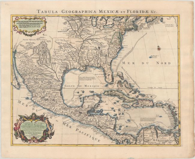
“Carte du Mexique et de la Floride des Terres Angloises et des Isles Antilles du Cours et des Environs de la Riviere de Mississipi...”
Map Maker:
Delisle/Covens & Mortier
This is the Covens & Mortier issue of Delisle's im... (full text available to subscribers)
| Item Detail |
| |
| |
MapMaker: |
Delisle/Covens & Mortier
|
|
| |
| |
Subject: |
Colonial Eastern North America & West Indies |
|
| |
Period/Size: |
1722 / 18.5" x 23.8" (47.0 x 60.5 cm)
|
|
| |
Color: |
Colored
|
|
| |
Condition: |
(A) A crisp impression on watermarked paper with a couple of short edge tears confined to the right blank margin that have been closed on verso with archival materials. (condition help) |
|
| |
Source: |
|
|
| |
References: |
Tooley (Amer) #51; Schwartz & Ehrenberg, plt. 82; Martin & Martin plt.17; cf. Brown (IMCOS #165) pp. 37-39; cf. Cummings (SE) #137. |
|
| |
|
|
| Sales Information |
| |
| |
Price: |
|
|
| |
| |
Offered by: |
Old World Auctions |
|
| |
Catalog: |
Auction No. 191 - Antique Maps, Charts, Atlases & Globes (9561) |
|
| |
Lot/Item #: |
107 |
|
| |
| |
Date: |
02/2023
|
|
| |
| |
|
Antique Maps - Valuation and Pricing, Descriptions, Resources |
|
Home |
Information |
Search |
Register |
Contact Us |
Site Map
Americana Exchange, Inc. © 1999 - 2024 Americana Exchange, Inc.. All rights reserved.
OldMaps.com, the OldMaps.com logo and
AMPR are service marks or registered service marks of Americana Exchange, Inc..
|