Title:
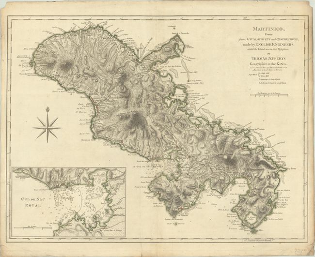
“Martinico, Done from Actual Surveys and Observations, Made by English Engineers Whilst the Island Was in Their Possession”
Map Maker:
Thomas Jefferys
This map was prepared by English engineers when Ma... (full text available to subscribers)
| Item Detail |
| |
| |
MapMaker: |
Thomas Jefferys
|
|
| |
| |
Subject: |
Martinique |
|
| |
Period/Size: |
1775 / 18.2" x 24.1" (46.3 x 61.3 cm)
|
|
| |
Color: |
Colored
|
|
| |
Condition: |
(A) Contemporary outline color on a sturdy sheet with a Strasburg Lily watermark. There is a slight printer's crease at bottom center and marginal soiling. There are small chips, crease, and tears in the corners of the sheet. (condition help) |
|
| |
Source: |
West Indian Atlas |
|
| |
References: |
Sellers & Van Ee #2063; Shirley (BL Atlases) M.JEF-4a #31. |
|
| |
|
|
| Sales Information |
| |
| |
Price: |
|
|
| |
| |
Offered by: |
Old World Auctions |
|
| |
Catalog: |
Auction No. 191 - Antique Maps, Charts, Atlases & Globes (9561) |
|
| |
Lot/Item #: |
397 |
|
| |
| |
Date: |
02/2023
|
|
| |
| |
|
Antique Maps - Valuation and Pricing, Descriptions, Resources |
|
Home |
Information |
Search |
Register |
Contact Us |
Site Map
Americana Exchange, Inc. © 1999 - 2024 Americana Exchange, Inc.. All rights reserved.
OldMaps.com, the OldMaps.com logo and
AMPR are service marks or registered service marks of Americana Exchange, Inc..
|