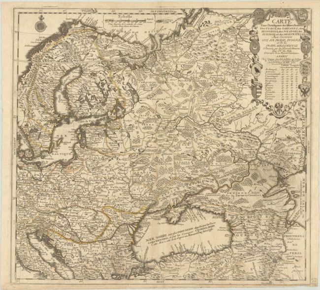
Title:
“Carte pour l'Intelligence des Affaires Presente, des Turcs, des Tartares, des Hongrois, des Polonois, des Suedois, et des Moscovites...”
Map Maker:
Nicholas de Fer
This fascinating map of Eastern Europe and the Rus... (full text available to subscribers)
| Item Detail |
| |
| |
MapMaker: |
Nicholas de Fer
|
|
| |
| |
Subject: |
Eastern Europe, Russia |
|
| |
Period/Size: |
1711 / 20.6" x 22.2" (52.4 x 56.4 cm)
|
|
| |
Color: |
Colored
|
|
| |
Condition: |
(B+) Contemporary outline color on a watermarked sheet with printer's ink residue at right, light soiling, and several worm tracks a bottom that have been closed on verso with old paper. Narrow bottom margin. (condition help) |
|
| |
Source: |
Atlas ou Recueil de Cartes Geographiques |
|
| |
References: |
Pastoureau, FER II C [59]. |
|
| |
|
|
| Sales Information |
| |
| |
Price: |
|
|
| |
| |
Offered by: |
Old World Auctions |
|
| |
Catalog: |
Auction No. 191 - Antique Maps, Charts, Atlases & Globes (9561) |
|
| |
Lot/Item #: |
582 |
|
| |
| |
Date: |
02/2023
|
|
| |
| |
|
Antique Maps - Valuation and Pricing, Descriptions, Resources |
|
Home |
Information |
Search |
Register |
Contact Us |
Site Map
Americana Exchange, Inc. © 1999 - 2024 Americana Exchange, Inc.. All rights reserved.
OldMaps.com, the OldMaps.com logo and
AMPR are service marks or registered service marks of Americana Exchange, Inc..
|