Title:
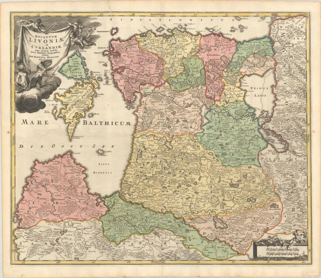
“Ducatuum Livoniae et Curlandiae cum Vicinis Insulis Nova Exhibitio Geographica”
Map Maker:
Johann Baptist Homann
This attractive map of Estonia and Latvia shows th... (full text available to subscribers)
| Item Detail |
| |
| |
MapMaker: |
Johann Baptist Homann
|
|
| |
| |
Subject: |
Estonia & Latvia |
|
| |
Period/Size: |
1716 / 19.2" x 22.9" (48.8 x 58.2 cm)
|
|
| |
Color: |
Colored
|
|
| |
Condition: |
(A) Fine impression and full contemporary coloring on thick hand laid paper with original margins and large coat of arms watermark. There is one small area of color offsetting in the Baltic and short printer's crease enters border at top left. (condition help) |
|
| |
Source: |
Grosser Atlas |
|
| |
References: |
|
|
| |
|
|
| Sales Information |
| |
| |
Price: |
|
|
| |
| |
Offered by: |
Old World Auctions |
|
| |
Catalog: |
Auction No. 191 - Antique Maps, Charts, Atlases & Globes (9561) |
|
| |
Lot/Item #: |
500 |
|
| |
| |
Date: |
02/2023
|
|
| |
| |
|
Antique Maps - Valuation and Pricing, Descriptions, Resources |
|
Home |
Information |
Search |
Register |
Contact Us |
Site Map
Americana Exchange, Inc. © 1999 - 2024 Americana Exchange, Inc.. All rights reserved.
OldMaps.com, the OldMaps.com logo and
AMPR are service marks or registered service marks of Americana Exchange, Inc..
|