Title:
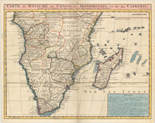
“Carte du Royaume de Congo, du Monomotapa et de la Cafrerie, Dressee sur les Memoires les Plus Exacts & les Observations les Plus Nouvelles”
Map Maker:
Henry Abraham Chatelain
This copper-engraved map is Chatelain's version of... (full text available to subscribers)
| Item Detail |
| |
| |
MapMaker: |
Henry Abraham Chatelain
|
|
| |
| |
Subject: |
Southern Africa & Madagascar |
|
| |
Period/Size: |
1720 / 16.0" x 20.6" (40.7 x 52.4 cm)
|
|
| |
Color: |
Colored
|
|
| |
Condition: |
(B+) A crisp impression on a bright sheet with a Strasburg Bend & Lily watermark and some errant color in the border at left and bottom. There is a short centerfold separation at top and another centerfold separation at bottom that extends to the Tropic (condition help) |
|
| |
Source: |
Atlas Historique |
|
| |
References: |
|
|
| |
|
|
| Sales Information |
| |
| |
Price: |
|
|
| |
| |
Offered by: |
Old World Auctions |
|
| |
Catalog: |
Auction No. 191 - Antique Maps, Charts, Atlases & Globes (9561) |
|
| |
Lot/Item #: |
761 |
|
| |
| |
Date: |
02/2023
|
|
| |
| |
|
Antique Maps - Valuation and Pricing, Descriptions, Resources |
|
Home |
Information |
Search |
Register |
Contact Us |
Site Map
Americana Exchange, Inc. © 1999 - 2024 Americana Exchange, Inc.. All rights reserved.
OldMaps.com, the OldMaps.com logo and
AMPR are service marks or registered service marks of Americana Exchange, Inc..
|