Title:
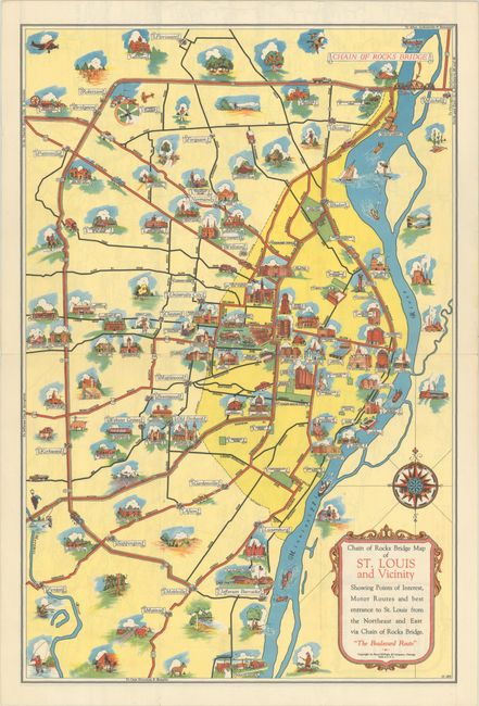
“Chain of Rocks Bridge Map of St. Louis and Vicinity Showing Points of Interest, Motor Routes and Best Entrance to St Louis...”
Map Maker:
Rand McNally& Co.
This charming pictorial map highlights the Chain o... (full text available to subscribers)
| Item Detail |
| |
| |
MapMaker: |
Rand McNally& Co.
|
|
| |
| |
Subject: |
St. Louis, Missouri |
|
| |
Period/Size: |
1940 / 16.5" x 11.0" (42.0 x 28.0 cm)
|
|
| |
Color: |
Colored
|
|
| |
Condition: |
(A) Issued folding with a hint of soiling along the edges of the pamphlet covers. (condition help) |
|
| |
Source: |
|
|
| |
References: |
Rumsey #11288. |
|
| |
|
|
| Sales Information |
| |
| |
Price: |
|
|
| |
| |
Offered by: |
Old World Auctions |
|
| |
Catalog: |
Auction No. 191 - Antique Maps, Charts, Atlases & Globes (9561) |
|
| |
Lot/Item #: |
297 |
|
| |
| |
Date: |
02/2023
|
|
| |
| |
|
Antique Maps - Valuation and Pricing, Descriptions, Resources |
|
Home |
Information |
Search |
Register |
Contact Us |
Site Map
Americana Exchange, Inc. © 1999 - 2024 Americana Exchange, Inc.. All rights reserved.
OldMaps.com, the OldMaps.com logo and
AMPR are service marks or registered service marks of Americana Exchange, Inc..
|