Title:
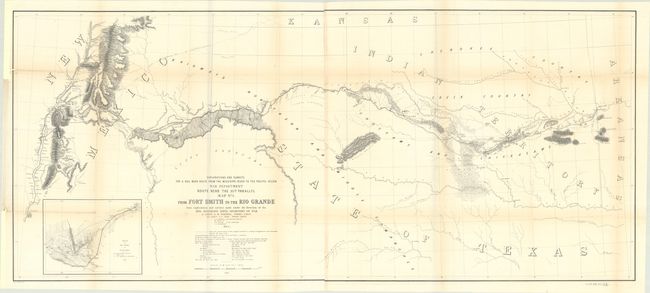
“Map No. 1. From Fort Smith to the Rio Grande from Explorations and Surveys Made Under the Direction of the Hon. Jefferson Davis, Secretary of War...”
Map Maker:
Amiel Weekes Whipple
This map covers the region from Fort Smith, Arkans... (full text available to subscribers)
| Item Detail |
| |
| |
MapMaker: |
Amiel Weekes Whipple
|
|
| |
| |
Subject: |
Western United States |
|
| |
Period/Size: |
1853-54 / 22.1" x 50.6" (56.2 x 128.6 cm)
|
|
| |
Color: |
Black & White
|
|
| |
Condition: |
(B+) A bright sheet, issued folding, with light toning along the folds and binding trims at left that have been replaced with paper. The map has been fully backed in archival tissue to repair several binding tears and some separations along the folds. (condition help) |
|
| |
Source: |
U.S. Pacific Railroad Surveys |
|
| |
References: |
Wheat (TMW) #874. |
|
| |
|
|
| Sales Information |
| |
| |
Price: |
|
|
| |
| |
Offered by: |
Old World Auctions |
|
| |
Catalog: |
Auction No. 191 - Antique Maps, Charts, Atlases & Globes (9561) |
|
| |
Lot/Item #: |
219 |
|
| |
| |
Date: |
02/2023
|
|
| |
| |
|
Antique Maps - Valuation and Pricing, Descriptions, Resources |
|
Home |
Information |
Search |
Register |
Contact Us |
Site Map
Americana Exchange, Inc. © 1999 - 2024 Americana Exchange, Inc.. All rights reserved.
OldMaps.com, the OldMaps.com logo and
AMPR are service marks or registered service marks of Americana Exchange, Inc..
|