Title:
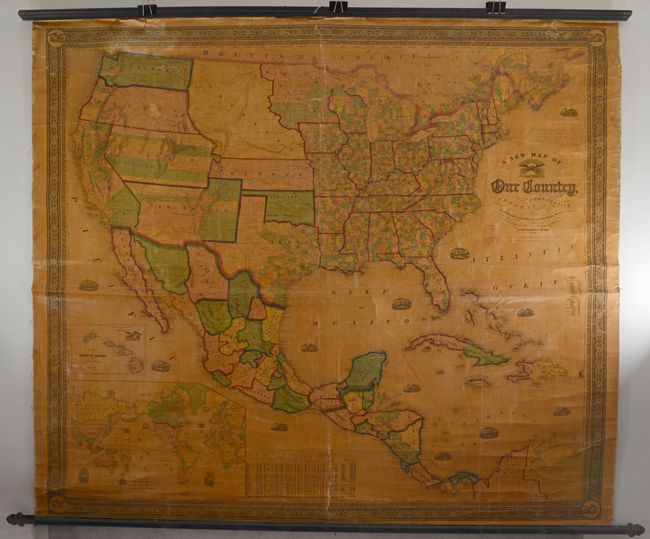
“A New Map of Our Country, Prospective and Present Compiled from Government Surveys and Other Reliable Sources”
Map Maker:
Gaston & Johnson
This majestic wall map was published just as the c... (full text available to subscribers)
| Item Detail |
| |
| |
MapMaker: |
Gaston & Johnson
|
|
| |
| |
Subject: |
United States |
|
| |
Period/Size: |
1856 / 55.5" x 63.4" (141.0 x 161.1 cm)
|
|
| |
Color: |
Colored
|
|
| |
Condition: |
(C+) Mostly clean and colorful and the varnish has not browned. The map is coming loose from the linen in places at top, and is partially detached from both the top and bottom rollers. There is a long horizontal crack extending across the middle of the (condition help) |
|
| |
Source: |
|
|
| |
References: |
|
|
| |
|
|
| Sales Information |
| |
| |
Price: |
|
|
| |
| |
Offered by: |
Old World Auctions |
|
| |
Catalog: |
Auction No. 191 - Antique Maps, Charts, Atlases & Globes (9561) |
|
| |
Lot/Item #: |
146 |
|
| |
| |
Date: |
02/2023
|
|
| |
| |
|
Antique Maps - Valuation and Pricing, Descriptions, Resources |
|
Home |
Information |
Search |
Register |
Contact Us |
Site Map
Americana Exchange, Inc. © 1999 - 2024 Americana Exchange, Inc.. All rights reserved.
OldMaps.com, the OldMaps.com logo and
AMPR are service marks or registered service marks of Americana Exchange, Inc..
|