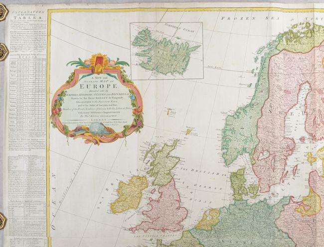
Title:
“A New and Accurate Map of Europe, Divided Into Its Empires, Kingdoms, States and Republics, &c...”
Map Maker:
Thomas Kitchin
This is Kitchin's version of Robert de Vaugondy's ... (full text available to subscribers)
| Item Detail |
| |
| |
MapMaker: |
Thomas Kitchin
|
|
| |
| |
Subject: |
Europe |
|
| |
Period/Size: |
1772 / 39.8" x 41.3" (101.1 x 104.9 cm)
|
|
| |
Color: |
Colored
|
|
| |
Condition: |
(B+) A nice impression on bright sheets with Strasburg Lily watermarks, very minor soiling, some extraneous creases, and tiny chips and tears along the edges of the sheet. There are a few short tears and fold separations in the image that have been archi (condition help) |
|
| |
Source: |
General Atlas |
|
| |
References: |
Phillips (Atlases) #653-3 & 4. |
|
| |
|
|
| Sales Information |
| |
| |
Price: |
|
|
| |
| |
Offered by: |
Old World Auctions |
|
| |
Catalog: |
Auction No. 191 - Antique Maps, Charts, Atlases & Globes (9561) |
|
| |
Lot/Item #: |
454 |
|
| |
| |
Date: |
02/2023
|
|
| |
| |
|
Antique Maps - Valuation and Pricing, Descriptions, Resources |
|
Home |
Information |
Search |
Register |
Contact Us |
Site Map
Americana Exchange, Inc. © 1999 - 2024 Americana Exchange, Inc.. All rights reserved.
OldMaps.com, the OldMaps.com logo and
AMPR are service marks or registered service marks of Americana Exchange, Inc..
|