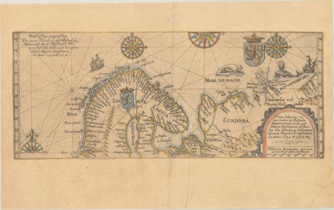
Title:
“Vera Delineatio Totius Tractus ex Hollandia Septentrionem Versus per Fretrum Nassouicum, ad Fluvium Oby Ducentes, ex Annotatione Iohannis Hugouis Lintschottani, de Annis 1594 et 1595, Etc.”
Map Maker:
Theodore de Bry
This handsome, boldly engraved map is derived from... (full text available to subscribers)
| Item Detail |
| |
| |
MapMaker: |
Theodore de Bry
|
|
| |
| |
Subject: |
Arctic & Scandinavia |
|
| |
Period/Size: |
1613 / 5.4" x 13.2" (13.8 x 33.6 cm)
|
|
| |
Color: |
Colored
|
|
| |
Condition: |
(B+) A crisp impression on a lightly toned sheet with the watermarks of a small coat of arms and a horn. There is a printer's crease at bottom center with a minor adjacent tear that has been archivally repaired. (condition help) |
|
| |
Source: |
|
|
| |
References: |
Ginsberg #49.2. |
|
| |
|
|
| Sales Information |
| |
| |
Price: |
|
|
| |
| |
Offered by: |
Old World Auctions |
|
| |
Catalog: |
Auction No. 191 - Antique Maps, Charts, Atlases & Globes (9561) |
|
| |
Lot/Item #: |
449 |
|
| |
| |
Date: |
02/2023
|
|
| |
| |
|
Antique Maps - Valuation and Pricing, Descriptions, Resources |
|
Home |
Information |
Search |
Register |
Contact Us |
Site Map
Americana Exchange, Inc. © 1999 - 2024 Americana Exchange, Inc.. All rights reserved.
OldMaps.com, the OldMaps.com logo and
AMPR are service marks or registered service marks of Americana Exchange, Inc..
|