Title:
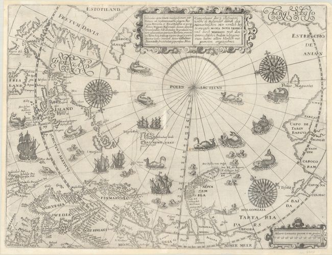
“Deliniatio Cartae Trium Navigationum per Batavos ad Septentrionalem Plagem Norvegia Moscovia et Nova Zembla... / Conterfactur der 3 Schiffarten Welche di Hollander durch das Mitnachtischen Mer Nemlich bey Norwegen Mosca Nova Zembla...”
Map Maker:
Theodore de Bry
This is one of the most decorative early maps of t... (full text available to subscribers)
| Item Detail |
| |
| |
MapMaker: |
Theodore de Bry
|
|
| |
| |
Subject: |
North Pole |
|
| |
Period/Size: |
1601 / 11.0" x 14.3" (28.0 x 36.4 cm)
|
|
| |
Color: |
Black & White
|
|
| |
Condition: |
(B+) A nice impression on a bright sheet with a double-sided cross watermark. There is a small hole at center and a tiny chip at top that have been professionally repaired with a minor amount of the rhumb lines replaced in facsimile. (condition help) |
|
| |
Source: |
Petits Voyages, Part III |
|
| |
References: |
Ginsberg #47. |
|
| |
|
|
| Sales Information |
| |
| |
Price: |
|
|
| |
| |
Offered by: |
Old World Auctions |
|
| |
Catalog: |
Auction No. 191 - Antique Maps, Charts, Atlases & Globes (9561) |
|
| |
Lot/Item #: |
45 |
|
| |
| |
Date: |
02/2023
|
|
| |
| |
|
Antique Maps - Valuation and Pricing, Descriptions, Resources |
|
Home |
Information |
Search |
Register |
Contact Us |
Site Map
Americana Exchange, Inc. © 1999 - 2024 Americana Exchange, Inc.. All rights reserved.
OldMaps.com, the OldMaps.com logo and
AMPR are service marks or registered service marks of Americana Exchange, Inc..
|