Title:
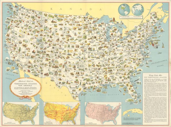
“Illustrierte Karte der Vereinigten Staaten von Amerika mit Darstellung der Regionalen Bodenschatze, Produkte und Landschaftlichen Besonderheiten”
Map Maker:
General Drafting Corp.
This pictorial map was created by General Drafting... (full text available to subscribers)
| Item Detail |
| |
| |
MapMaker: |
General Drafting Corp.
|
|
| |
| |
Subject: |
United States |
|
| |
Period/Size: |
1952 / 23.2" x 31.3" (59.0 x 79.5 cm)
|
|
| |
Color: |
Colored
|
|
| |
Condition: |
(A) This map was issued folding and has been backed in linen with minor extraneous creasing and wear along the folds. There is light soiling that is mostly confined to the blank margins, with the exception of a bit at bottom center. (condition help) |
|
| |
Source: |
|
|
| |
References: |
P.J. Mode Collection #1368; Rumsey #12475. |
|
| |
|
|
| Sales Information |
| |
| |
Price: |
|
|
| |
| |
Offered by: |
Old World Auctions |
|
| |
Catalog: |
Auction No. 191 - Antique Maps, Charts, Atlases & Globes (9561) |
|
| |
Lot/Item #: |
160 |
|
| |
| |
Date: |
02/2023
|
|
| |
| |
|
Antique Maps - Valuation and Pricing, Descriptions, Resources |
|
Home |
Information |
Search |
Register |
Contact Us |
Site Map
Americana Exchange, Inc. © 1999 - 2024 Americana Exchange, Inc.. All rights reserved.
OldMaps.com, the OldMaps.com logo and
AMPR are service marks or registered service marks of Americana Exchange, Inc..
|