Title:
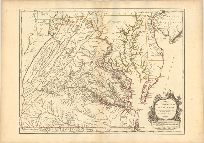
“Carte de la Virginie et du Maryland Dressee sur la Grande Carte Angloise de Mrs. Josue Fry et Pierre Jefferson...”
Map Maker:
Didier Robert de Vaugondy
This handsome map is the French edition of the Fry... (full text available to subscribers)
| Item Detail |
| |
| |
MapMaker: |
Didier Robert de Vaugondy
|
|
| |
| |
Subject: |
Colonial Mid-Atlantic United States |
|
| |
Period/Size: |
1755 / 19.1" x 25.2" (48.6 x 64.0 cm)
|
|
| |
Color: |
Colored
|
|
| |
Condition: |
(B+) Contemporary outline color with light toning along the centerfold and scattered foxing that is mostly in the blank margins. (condition help) |
|
| |
Source: |
Atlas Universel |
|
| |
References: |
cf. Cumming (SE) #281; Pedley #470; Phillips (M) p. 49; Sellers & Van Ee #1432. |
|
| |
|
|
| Sales Information |
| |
| |
Price: |
|
|
| |
| |
Offered by: |
Old World Auctions |
|
| |
Catalog: |
Auction No. 191 - Antique Maps, Charts, Atlases & Globes (9561) |
|
| |
Lot/Item #: |
185 |
|
| |
| |
Date: |
02/2023
|
|
| |
| |
|
Antique Maps - Valuation and Pricing, Descriptions, Resources |
|
Home |
Information |
Search |
Register |
Contact Us |
Site Map
Americana Exchange, Inc. © 1999 - 2024 Americana Exchange, Inc.. All rights reserved.
OldMaps.com, the OldMaps.com logo and
AMPR are service marks or registered service marks of Americana Exchange, Inc..
|