Title:
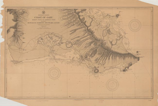
“Hawaiian Islands - Coast of Oahu Mokapu Point to Barbers Point Including Honolulu Harbor and Pearl Lochs...”
Map Maker:
U.S. Navy Dept.
A highly detailed chart presenting the southern co... (full text available to subscribers)
| Item Detail |
| |
| |
MapMaker: |
U.S. Navy Dept.
|
|
| |
| |
Subject: |
Oahu, Hawaii |
|
| |
Period/Size: |
1910 / 23.6" x 37.8" (60.0 x 96.1 cm)
|
|
| |
Color: |
Black & White
|
|
| |
Condition: |
(B) On a lightly toned sheet with some minor staining and a few repaired edge tears at bottom that just enter the border. There are a number of edge chips that are mostly confined to the blank margins with the exception at bottom left with a tiny amount (condition help) |
|
| |
Source: |
|
|
| |
References: |
|
|
| |
|
|
| Sales Information |
| |
| |
Price: |
|
|
| |
| |
Offered by: |
Old World Auctions |
|
| |
Catalog: |
Auction No. 191 - Antique Maps, Charts, Atlases & Globes (9561) |
|
| |
Lot/Item #: |
277 |
|
| |
| |
Date: |
02/2023
|
|
| |
| |
|
Antique Maps - Valuation and Pricing, Descriptions, Resources |
|
Home |
Information |
Search |
Register |
Contact Us |
Site Map
Americana Exchange, Inc. © 1999 - 2024 Americana Exchange, Inc.. All rights reserved.
OldMaps.com, the OldMaps.com logo and
AMPR are service marks or registered service marks of Americana Exchange, Inc..
|