Title:
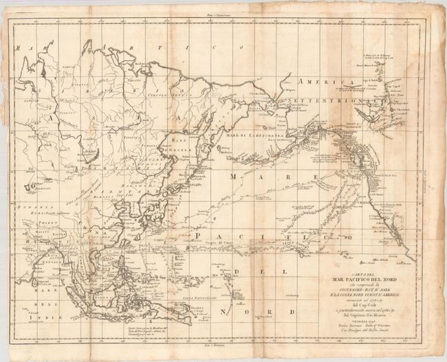
“Carta del Mar Pacifico del Nord che Comprende la Costa Nord-Est d'Asia e la Costa Nord Ouest d'America Riconosciute nel 1778 e 79 dal Cap. Cook...”
Map Maker:
Capt. John Meares
This is the scarce first Italian version of Meares... (full text available to subscribers)
| Item Detail |
| |
| |
MapMaker: |
Capt. John Meares
|
|
| |
| |
Subject: |
North Pacific Ocean |
|
| |
Period/Size: |
1796 / 18.1" x 22.9" (46.0 x 58.2 cm)
|
|
| |
Color: |
Black & White
|
|
| |
Condition: |
(B) Issued folding on watermarked paper with light toning and offsetting. There is a binding trim at left and a related short binding tear that has been closed on verso with archival tape. (condition help) |
|
| |
Source: |
Raccolta di Tutti Viaggi Fatti Intorno Al Mondo da Diverse Nazioni dell'Europa |
|
| |
References: |
McGuirk #225. |
|
| |
|
|
| Sales Information |
| |
| |
Price: |
|
|
| |
| |
Offered by: |
Old World Auctions |
|
| |
Catalog: |
Auction No. 192 - Antique Maps, Charts, Atlases & Globes (9562) |
|
| |
Lot/Item #: |
687 |
|
| |
| |
Date: |
04/2023
|
|
| |
| |
|
Antique Maps - Valuation and Pricing, Descriptions, Resources |
|
Home |
Information |
Search |
Register |
Contact Us |
Site Map
Americana Exchange, Inc. © 1999 - 2024 Americana Exchange, Inc.. All rights reserved.
OldMaps.com, the OldMaps.com logo and
AMPR are service marks or registered service marks of Americana Exchange, Inc..
|