Title:
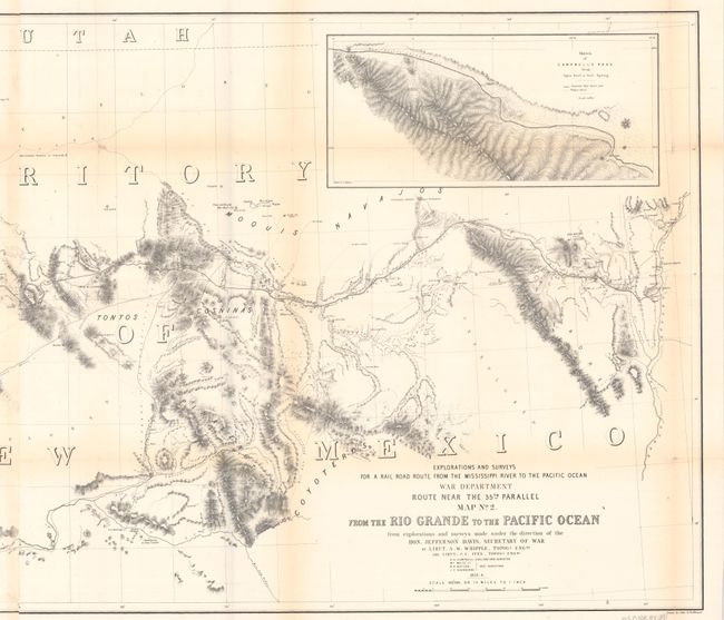
“Map No. 2. From the Rio Grande to the Pacific Ocean from Explorations and Surveys Made Under the Direction of the Hon. Jefferson Davis, Secretary of War...”
Map Maker:
Amiel Weekes Whipple
An impressive, immense map that covers the railroa... (full text available to subscribers)
| Item Detail |
| |
| |
MapMaker: |
Amiel Weekes Whipple
|
|
| |
| |
Subject: |
Southwestern United States |
|
| |
Period/Size: |
1853-54 / 22.1" x 50.3" (56.2 x 127.8 cm)
|
|
| |
Color: |
Black & White
|
|
| |
Condition: |
(B) Issued folding and backed in archival tissue with light toning along the folds and archival repairs to fold separations, including a 7" split at top left with a small associated chip. Binding trims at left have been replaced with paper, with a portio (condition help) |
|
| |
Source: |
U.S. Pacific Railroad Surveys |
|
| |
References: |
Wheat (TMW) #875. |
|
| |
|
|
| Sales Information |
| |
| |
Price: |
|
|
| |
| |
Offered by: |
Old World Auctions |
|
| |
Catalog: |
Auction No. 192 - Antique Maps, Charts, Atlases & Globes (9562) |
|
| |
Lot/Item #: |
215 |
|
| |
| |
Date: |
04/2023
|
|
| |
| |
|
Antique Maps - Valuation and Pricing, Descriptions, Resources |
|
Home |
Information |
Search |
Register |
Contact Us |
Site Map
Americana Exchange, Inc. © 1999 - 2024 Americana Exchange, Inc.. All rights reserved.
OldMaps.com, the OldMaps.com logo and
AMPR are service marks or registered service marks of Americana Exchange, Inc..
|