Title:
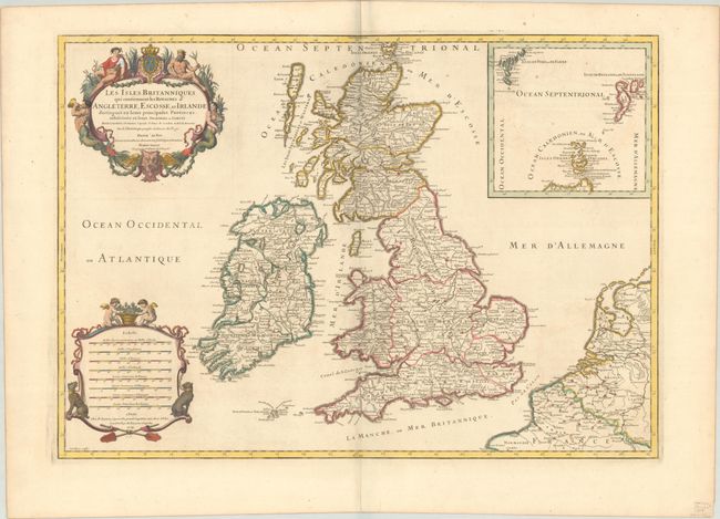
“Les Isles Britanniques qui Contiennent les Royaumes d'Angleterre, Escosse, et Irlande Distingues en Leurs Principales Provinces...”
Map Maker:
Sanson/Jaillot
This is an attractive map of the British Isles fil... (full text available to subscribers)
| Item Detail |
| |
| |
MapMaker: |
Sanson/Jaillot
|
|
| |
| |
Subject: |
Britain |
|
| |
Period/Size: |
1709 / 18.1" x 25.6" (46.0 x 65.1 cm)
|
|
| |
Color: |
Colored
|
|
| |
Condition: |
(B+) A nice impression on a bright sheet with the watermark of a Maltese cross encircled in rosary beads. There is very light offsetting and a few spots of foxing. (condition help) |
|
| |
Source: |
Atlas Francois |
|
| |
References: |
Shirley (BI to 1750) Jaillot 3. |
|
| |
|
|
| Sales Information |
| |
| |
Price: |
|
|
| |
| |
Offered by: |
Old World Auctions |
|
| |
Catalog: |
Auction No. 192 - Antique Maps, Charts, Atlases & Globes (9562) |
|
| |
Lot/Item #: |
399 |
|
| |
| |
Date: |
04/2023
|
|
| |
| |
|
Antique Maps - Valuation and Pricing, Descriptions, Resources |
|
Home |
Information |
Search |
Register |
Contact Us |
Site Map
Americana Exchange, Inc. © 1999 - 2024 Americana Exchange, Inc.. All rights reserved.
OldMaps.com, the OldMaps.com logo and
AMPR are service marks or registered service marks of Americana Exchange, Inc..
|