Title:
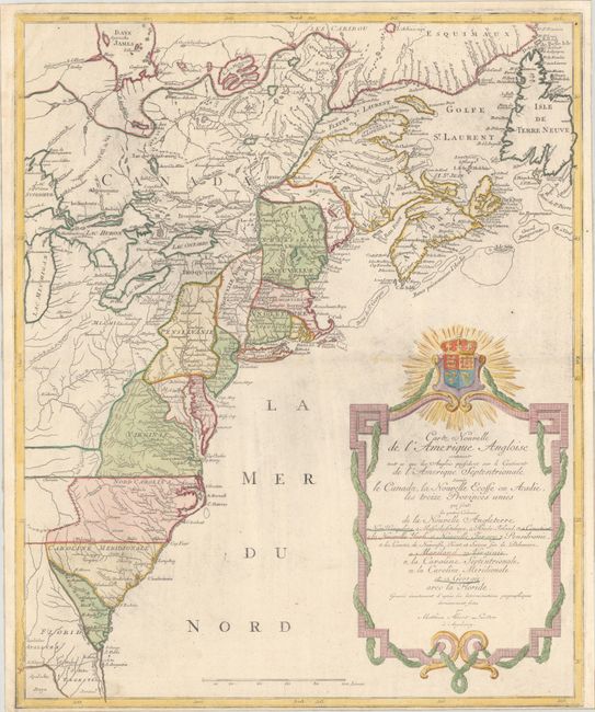
“Carte Nouvelle de l'Amerique Angloise Contenant tout ce que les Anglois Possedent sur le Continent de l'Amerique Septentrionale Savoir le Canada, la Nouvelle Ecosse ou Acadie, les Treize Provinces Unies...”
Map Maker:
Mathias Albrecht Lotter
This handsome map was issued shortly before the ou... (full text available to subscribers)
| Item Detail |
| |
| |
MapMaker: |
Mathias Albrecht Lotter
|
|
| |
| |
Subject: |
Colonial Eastern United States & Canada |
|
| |
Period/Size: |
1777 / 23.6" x 19.4" (60.0 x 49.3 cm)
|
|
| |
Color: |
Colored
|
|
| |
Condition: |
(A) A bright sheet with light printer's ink residue and a very narrow bottom margin. The edges of the sheet have been reinforced on verso with archival tissue. (condition help) |
|
| |
Source: |
|
|
| |
References: |
McCorkle #776.19; Sellers & Van Ee #141. |
|
| |
|
|
| Sales Information |
| |
| |
Price: |
|
|
| |
| |
Offered by: |
Old World Auctions |
|
| |
Catalog: |
Auction No. 192 - Antique Maps, Charts, Atlases & Globes (9562) |
|
| |
Lot/Item #: |
127 |
|
| |
| |
Date: |
04/2023
|
|
| |
| |
|
Antique Maps - Valuation and Pricing, Descriptions, Resources |
|
Home |
Information |
Search |
Register |
Contact Us |
Site Map
Americana Exchange, Inc. © 1999 - 2024 Americana Exchange, Inc.. All rights reserved.
OldMaps.com, the OldMaps.com logo and
AMPR are service marks or registered service marks of Americana Exchange, Inc..
|