Title:
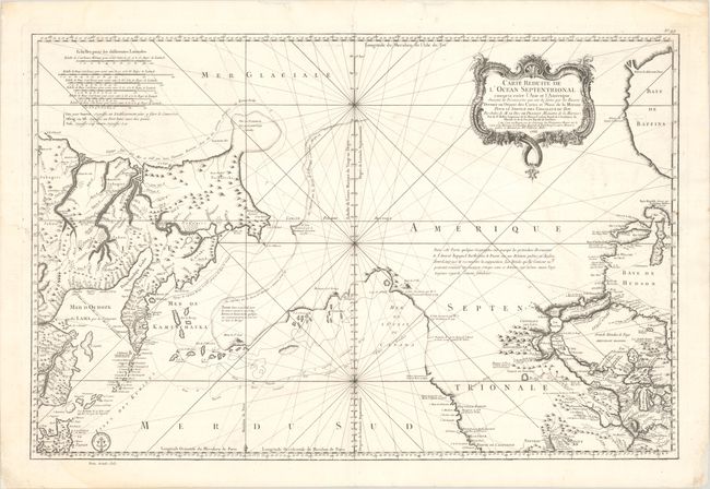
“Carte Reduite de l'Ocean Septentrional Compris Entre l'Asie et l'Amerique, Suivant les Decouvertes qui ont ete Faites par les Russes...”
Map Maker:
Jacques Nicolas Bellin
This captivating large-scale chart depicts the Nor... (full text available to subscribers)
| Item Detail |
| |
| |
MapMaker: |
Jacques Nicolas Bellin
|
|
| |
| |
Subject: |
Western North America & North Pacific Ocean |
|
| |
Period/Size: |
1766 / 22.1" x 33.4" (56.2 x 84.9 cm)
|
|
| |
Color: |
Black & White
|
|
| |
Condition: |
(B+) A sharp impression on a bright sheet with minor offsetting, a few small spots, and very faint dampstains at the top and bottom of the sheet. There are archival repairs to some chips and tears along the edges of the sheet. (condition help) |
|
| |
Source: |
Hydrographie Francoise |
|
| |
References: |
Falk #1766-1; Kershaw #1126; McGuirk #133; Tooley (MCC-96) #771; Wagner #610. |
|
| |
|
|
| Sales Information |
| |
| |
Price: |
|
|
| |
| |
Offered by: |
Old World Auctions |
|
| |
Catalog: |
Auction No. 192 - Antique Maps, Charts, Atlases & Globes (9562) |
|
| |
Lot/Item #: |
104 |
|
| |
| |
Date: |
04/2023
|
|
| |
| |
|
Antique Maps - Valuation and Pricing, Descriptions, Resources |
|
Home |
Information |
Search |
Register |
Contact Us |
Site Map
Americana Exchange, Inc. © 1999 - 2024 Americana Exchange, Inc.. All rights reserved.
OldMaps.com, the OldMaps.com logo and
AMPR are service marks or registered service marks of Americana Exchange, Inc..
|