Title:
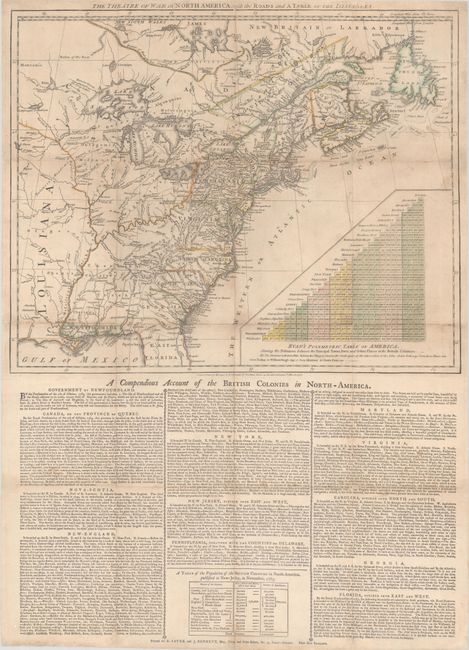
“The Theatre of War in North America, with the Roads and a Table of the Distances”
Map Maker:
Robert Sayer & John Bennett
This is the first state of an important early broa... (full text available to subscribers)
| Item Detail |
| |
| |
MapMaker: |
Robert Sayer & John Bennett
|
|
| |
| |
Subject: |
Colonial Eastern United States & Canada |
|
| |
Period/Size: |
1776 / 16.1" x 20.1" (40.9 x 51.1 cm)
|
|
| |
Color: |
Colored
|
|
| |
Condition: |
(B+) Issued folding on watermarked paper and now flat with light soiling. The folds have been professionally reinforced on verso to repair numerous fold separations with occasional minor loss at the fold junctions. (condition help) |
|
| |
Source: |
|
|
| |
References: |
McCorkle #776.26; Nebenzahl & Higginbotham pp. 206-208; Sellers & Van Ee #144; Stevens & Tree (Tooley) #58. |
|
| |
|
|
| Sales Information |
| |
| |
Price: |
|
|
| |
| |
Offered by: |
Old World Auctions |
|
| |
Catalog: |
Auction No. 190 - Antique Maps, Charts, Atlases & Globes (9560) |
|
| |
Lot/Item #: |
102 |
|
| |
| |
Date: |
11/2022
|
|
| |
| |
|
Antique Maps - Valuation and Pricing, Descriptions, Resources |
|
Home |
Information |
Search |
Register |
Contact Us |
Site Map
Americana Exchange, Inc. © 1999 - 2024 Americana Exchange, Inc.. All rights reserved.
OldMaps.com, the OldMaps.com logo and
AMPR are service marks or registered service marks of Americana Exchange, Inc..
|