Title:
“Preliminary Report of the United States Geological Survey of Montana and Portions of Adjacent Territories; Being a Fifth Annual Report of Progress”
Map Maker:
Ferdinand Vandeveer Hayden
Hayden, an American geologist, led the first feder... (full text available to subscribers)
| Item Detail |
| |
| |
MapMaker: |
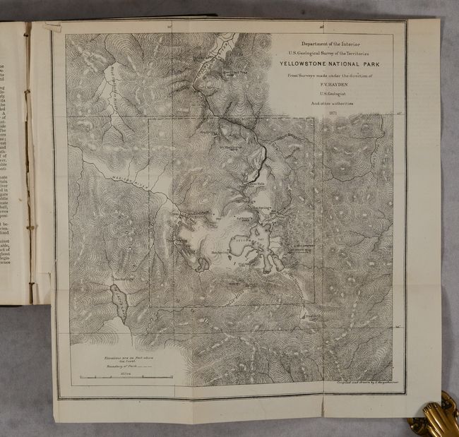
Ferdinand Vandeveer Hayden
|
|
| |
| |
Subject: |
Montana, Wyoming & Yellowstone |
|
| |
Period/Size: |
1872 / 9.1" x 5.8" (23.2 x 14.8 cm)
|
|
| |
Color: |
Black & White
|
|
| |
Condition: |
(B+) Contents are clean, bright and near fine. The Yellowstone National Park map has a 0.5" binding tear at left that has been closed on verso with archival tape. Front hinge is starting and the spine backstrip is chipped at top and loose on one side. (condition help) |
|
| |
Source: |
|
|
| |
References: |
|
|
| |
|
|
| Sales Information |
| |
| |
Price: |
|
|
| |
| |
Offered by: |
Old World Auctions |
|
| |
Catalog: |
Auction No. 190 - Antique Maps, Charts, Atlases & Globes (9560) |
|
| |
Lot/Item #: |
226 |
|
| |
| |
Date: |
11/2022
|
|
| |
| |
|
Antique Maps - Valuation and Pricing, Descriptions, Resources |
|
Home |
Information |
Search |
Register |
Contact Us |
Site Map
Americana Exchange, Inc. © 1999 - 2024 Americana Exchange, Inc.. All rights reserved.
OldMaps.com, the OldMaps.com logo and
AMPR are service marks or registered service marks of Americana Exchange, Inc..
|