Title:
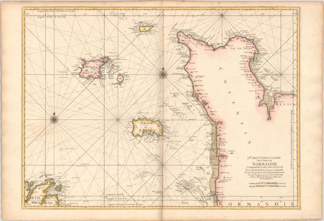
“2me. Carte Particuliere des Costes de Normandie Contenant les Costes du Cotentin Depuis la Pointe de la Percee Jusqu'a Granville ou sont Comprises les Isles de Jerzey, Grenezey, Cers, & Aurigny...”
Map Maker:
Jacques Nicolas Bellin
This chart depicts the coastline of the Cotentin P... (full text available to subscribers)
| Item Detail |
| |
| |
MapMaker: |
Jacques Nicolas Bellin
|
|
| |
| |
Subject: |
Northwestern France & Channel Islands |
|
| |
Period/Size: |
1770 / 23.4" x 32.0" (59.5 x 81.3 cm)
|
|
| |
Color: |
Colored
|
|
| |
Condition: |
(B+) A nice impression on a sturdy sheet with a light dampstain adjacent to the compass rose at left and a bit of toning along the centerfold and edges of the sheet. There is a bit of a grayish shadow along the centerfold and in the blank margins that is (condition help) |
|
| |
Source: |
|
|
| |
References: |
cf. Pastoureau, NEPTUNE FRANCAIS D #17. |
|
| |
|
|
| Sales Information |
| |
| |
Price: |
|
|
| |
| |
Offered by: |
Old World Auctions |
|
| |
Catalog: |
Auction No. 190 - Antique Maps, Charts, Atlases & Globes (9560) |
|
| |
Lot/Item #: |
419 |
|
| |
| |
Date: |
11/2022
|
|
| |
| |
|
Antique Maps - Valuation and Pricing, Descriptions, Resources |
|
Home |
Information |
Search |
Register |
Contact Us |
Site Map
Americana Exchange, Inc. © 1999 - 2024 Americana Exchange, Inc.. All rights reserved.
OldMaps.com, the OldMaps.com logo and
AMPR are service marks or registered service marks of Americana Exchange, Inc..
|