Title:
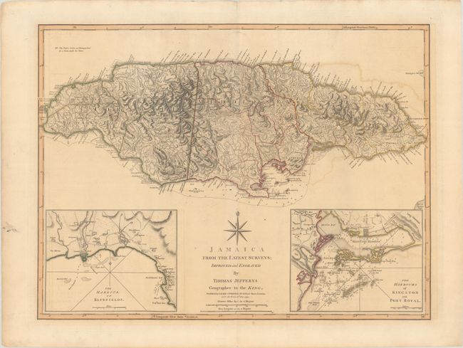
“Jamaica from the Latest Surveys”
Map Maker:
Jefferys/Laurie & Whittle
This detailed map of Jamaica shows the parishes, t... (full text available to subscribers)
| Item Detail |
| |
| |
MapMaker: |
Jefferys/Laurie & Whittle
|
|
| |
| |
Subject: |
Jamaica |
|
| |
Period/Size: |
1794 / 18.1" x 24.1" (46.0 x 61.3 cm)
|
|
| |
Color: |
Colored
|
|
| |
Condition: |
(B+) A nice impression with contemporary outline color with light offsetting and toning and short centerfold separations in the top and bottom blank margins. There are remnants of hinge tape on verso. (condition help) |
|
| |
Source: |
|
|
| |
References: |
Kapp (MCC-42) #101; cf. Shirley (BL Atlases) M.JEF-4a #24. |
|
| |
|
|
| Sales Information |
| |
| |
Price: |
|
|
| |
| |
Offered by: |
Old World Auctions |
|
| |
Catalog: |
Auction No. 190 - Antique Maps, Charts, Atlases & Globes (9560) |
|
| |
Lot/Item #: |
283 |
|
| |
| |
Date: |
11/2022
|
|
| |
| |
|
Antique Maps - Valuation and Pricing, Descriptions, Resources |
|
Home |
Information |
Search |
Register |
Contact Us |
Site Map
Americana Exchange, Inc. © 1999 - 2024 Americana Exchange, Inc.. All rights reserved.
OldMaps.com, the OldMaps.com logo and
AMPR are service marks or registered service marks of Americana Exchange, Inc..
|