Title:
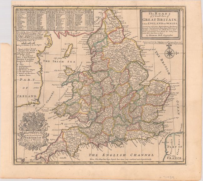
“The Roads of ye South Part of Great Britain, Called England and Wales. Containing All ye Cities, Mark et Towns, Post Towns, Boroughs...”
Map Maker:
Herman Moll
A detailed map of England and Wales presenting the... (full text available to subscribers)
| Item Detail |
| |
| |
MapMaker: |
Herman Moll
|
|
| |
| |
Subject: |
England & Wales |
|
| |
Period/Size: |
1732 / 10.9" x 11.9" (27.7 x 30.3 cm)
|
|
| |
Color: |
Colored
|
|
| |
Condition: |
(A) Issued folding with contemporary outline color on paper with a coat of arms watermark. There is a binder's trim at top left and an associated tiny tear in the map border. (condition help) |
|
| |
Source: |
|
|
| |
References: |
|
|
| |
|
|
| Sales Information |
| |
| |
Price: |
|
|
| |
| |
Offered by: |
Old World Auctions |
|
| |
Catalog: |
Auction No. 190 - Antique Maps, Charts, Atlases & Globes (9560) |
|
| |
Lot/Item #: |
358 |
|
| |
| |
Date: |
11/2022
|
|
| |
| |
|
Antique Maps - Valuation and Pricing, Descriptions, Resources |
|
Home |
Information |
Search |
Register |
Contact Us |
Site Map
Americana Exchange, Inc. © 1999 - 2024 Americana Exchange, Inc.. All rights reserved.
OldMaps.com, the OldMaps.com logo and
AMPR are service marks or registered service marks of Americana Exchange, Inc..
|