Title:
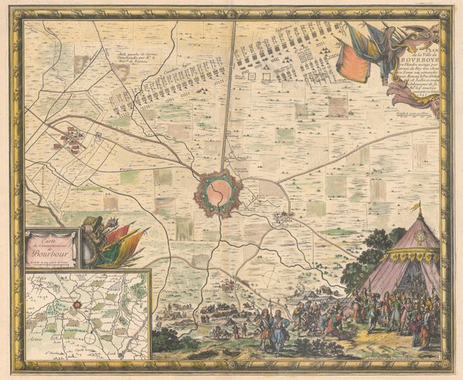
“Plan de la Ville de Bourbour en Flandre, Assiege par Larmee du Roy...”
Map Maker:
Sebastian de Pontault Sieur de Beaulieu
This intricately engraved map is centered on the f... (full text available to subscribers)
| Item Detail |
| |
| |
MapMaker: |
Sebastian de Pontault Sieur de Beaulieu
|
|
| |
| |
Subject: |
Northern France |
|
| |
Period/Size: |
1667 / 17.5" x 21.1" (44.5 x 53.6 cm)
|
|
| |
Color: |
Colored
|
|
| |
Condition: |
(A) A nice impression on watermarked paper with some minor edge chips confined to the far blank margins. (condition help) |
|
| |
Source: |
Plans et Profils du Comte De Flandre... |
|
| |
References: |
Pastoureau, BEAULIEU VII Aa [7]. |
|
| |
|
|
| Sales Information |
| |
| |
Price: |
|
|
| |
| |
Offered by: |
Old World Auctions |
|
| |
Catalog: |
Auction No. 190 - Antique Maps, Charts, Atlases & Globes (9560) |
|
| |
Lot/Item #: |
416 |
|
| |
| |
Date: |
11/2022
|
|
| |
| |
|
Antique Maps - Valuation and Pricing, Descriptions, Resources |
|
Home |
Information |
Search |
Register |
Contact Us |
Site Map
Americana Exchange, Inc. © 1999 - 2024 Americana Exchange, Inc.. All rights reserved.
OldMaps.com, the OldMaps.com logo and
AMPR are service marks or registered service marks of Americana Exchange, Inc..
|