Title:
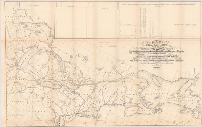
“Map of the Province of Canada, and the Lower Colonies, Shewing the Connection by Steam Navigation with New York, Pennsylvania, Ohio, Indiana, Illinois, Michigan, Wisconsin & Minnesota...”
Map Maker:
Thomas C. Keefer
This fascinating persuasive map is presented on a ... (full text available to subscribers)
| Item Detail |
| |
| |
MapMaker: |
Thomas C. Keefer
|
|
| |
| |
Subject: |
Northeastern United States & Canada |
|
| |
Period/Size: |
1855 / 25.0" x 38.9" (63.5 x 98.8 cm)
|
|
| |
Color: |
Black & White
|
|
| |
Condition: |
(B+) Issued folding with minor toning along the fold lines and faint offsetting. (condition help) |
|
| |
Source: |
|
|
| |
References: |
|
|
| |
|
|
| Sales Information |
| |
| |
Price: |
|
|
| |
| |
Offered by: |
Old World Auctions |
|
| |
Catalog: |
Auction No. 190 - Antique Maps, Charts, Atlases & Globes (9560) |
|
| |
Lot/Item #: |
110 |
|
| |
| |
Date: |
11/2022
|
|
| |
| |
|
Antique Maps - Valuation and Pricing, Descriptions, Resources |
|
Home |
Information |
Search |
Register |
Contact Us |
Site Map
Americana Exchange, Inc. © 1999 - 2024 Americana Exchange, Inc.. All rights reserved.
OldMaps.com, the OldMaps.com logo and
AMPR are service marks or registered service marks of Americana Exchange, Inc..
|