Title:
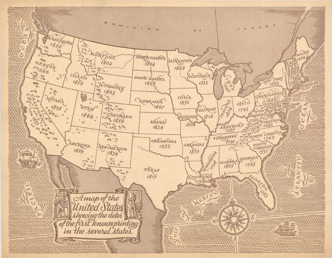
“A Map of the United States Showing the Dates of the First Known Printing in the Several States”
This simple, but informative, thematic map by B.A.... (full text available to subscribers)
| Item Detail |
| |
| |
MapMaker: |
(none given)
|
|
| |
| |
Subject: |
United States |
|
| |
Period/Size: |
1940 / 10.4" x 13.4" (26.5 x 34.1 cm)
|
|
| |
Color: |
Black & White
|
|
| |
Condition: |
(B+) On heavy tan paper with minor creases in the corners of the sheet and a short tear along the top sheet edge that has been closed on verso with archival tape. (condition help) |
|
| |
Source: |
|
|
| |
References: |
|
|
| |
|
|
| Sales Information |
| |
| |
Price: |
|
|
| |
| |
Offered by: |
Old World Auctions |
|
| |
Catalog: |
Auction No. 190 - Antique Maps, Charts, Atlases & Globes (9560) |
|
| |
Lot/Item #: |
123 |
|
| |
| |
Date: |
11/2022
|
|
| |
| |
|
Antique Maps - Valuation and Pricing, Descriptions, Resources |
|
Home |
Information |
Search |
Register |
Contact Us |
Site Map
Americana Exchange, Inc. © 1999 - 2024 Americana Exchange, Inc.. All rights reserved.
OldMaps.com, the OldMaps.com logo and
AMPR are service marks or registered service marks of Americana Exchange, Inc..
|