Title:
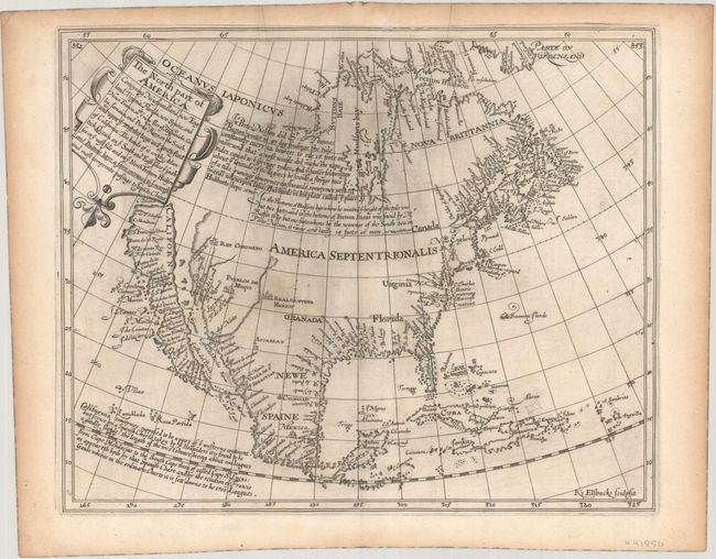
“The North Part of America Conteyning Newfoundland, New England, Virginia, Florida, New Spaine, and Nova Francia...”
Map Maker:
Henry Briggs
This is the first English map, and very likely the... (full text available to subscribers)
| Item Detail |
| |
| |
MapMaker: |
Henry Briggs
|
|
| |
| |
Subject: |
Colonial North America |
|
| |
Period/Size: |
1625 / 11.2" x 13.8" (28.5 x 35.1 cm)
|
|
| |
Color: |
Black & White
|
|
| |
Condition: |
(A) A dark impression with some minor printer's ink residue at center and light toning along the sheet edges. (condition help) |
|
| |
Source: |
Hakluytus Postumus or Purchas His Pilgrimes |
|
| |
References: |
Burden #214; McLaughlin #2; Wagner (NW) #295; Wheat (TMW) #38. |
|
| |
|
|
| Sales Information |
| |
| |
Price: |
|
|
| |
| |
Offered by: |
Old World Auctions |
|
| |
Catalog: |
Auction No. 190 - Antique Maps, Charts, Atlases & Globes (9560) |
|
| |
Lot/Item #: |
69 |
|
| |
| |
Date: |
11/2022
|
|
| |
| |
|
Antique Maps - Valuation and Pricing, Descriptions, Resources |
|
Home |
Information |
Search |
Register |
Contact Us |
Site Map
Americana Exchange, Inc. © 1999 - 2024 Americana Exchange, Inc.. All rights reserved.
OldMaps.com, the OldMaps.com logo and
AMPR are service marks or registered service marks of Americana Exchange, Inc..
|