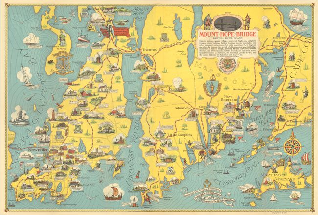
Title:
“Newport and the Historic Island of Rhode Island”
Map Maker:
H.W. Hetherington
A charming pictorial map extending from Bristol an... (full text available to subscribers)
| Item Detail |
| |
| |
MapMaker: |
H.W. Hetherington
|
|
| |
| |
Subject: |
Rhode Island & Massachusetts |
|
| |
Period/Size: |
1939 / 17.3" x 25.6" (44.0 x 65.1 cm)
|
|
| |
Color: |
Colored
|
|
| |
Condition: |
(A) A clean and colorful example with one tiny puncture hole (adjacent to Bournedale) that has been archivally repaired on verso. Issued folding. (condition help) |
|
| |
Source: |
|
|
| |
References: |
Hornsby (Picturing America) #82; Rumsey #8737. |
|
| |
|
|
| Sales Information |
| |
| |
Price: |
|
|
| |
| |
Offered by: |
Old World Auctions |
|
| |
Catalog: |
Auction No. 193 - Antique Maps, Charts, Atlases & Globes (9567) |
|
| |
Lot/Item #: |
296 |
|
| |
| |
Date: |
07/2023
|
|
| |
| |
|
Antique Maps - Valuation and Pricing, Descriptions, Resources |
|
Home |
Information |
Search |
Register |
Contact Us |
Site Map
Americana Exchange, Inc. © 1999 - 2024 Americana Exchange, Inc.. All rights reserved.
OldMaps.com, the OldMaps.com logo and
AMPR are service marks or registered service marks of Americana Exchange, Inc..
|