Title:
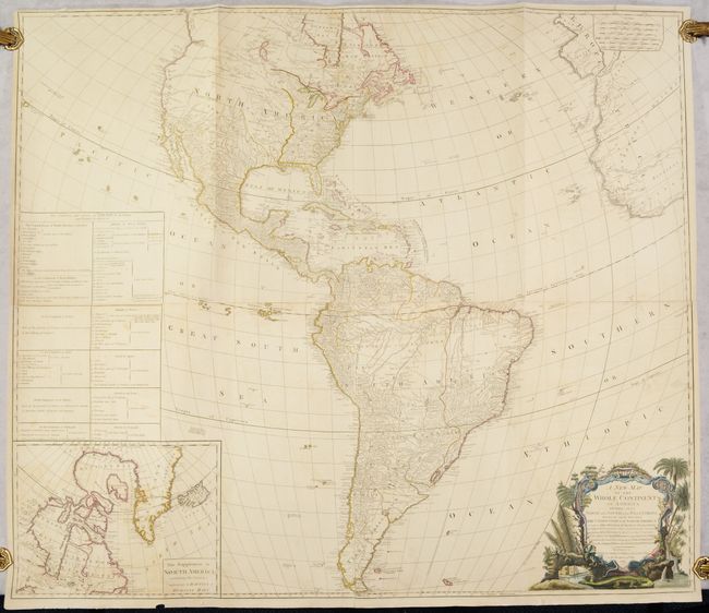
“A New Map of the Whole Continent of America, Divided into North and South and West Indies. Wherein Are Exactly Described the United States of North America...”
Map Maker:
Laurie & Whittle
An impressive, four-sheet map of North and South A... (full text available to subscribers)
| Item Detail |
| |
| |
MapMaker: |
Laurie & Whittle
|
|
| |
| |
Subject: |
Western Hemisphere - America |
|
| |
Period/Size: |
1794 / 40.6" x 46.8" (103.2 x 118.9 cm)
|
|
| |
Color: |
Colored
|
|
| |
Condition: |
(B+) Contemporary outline color with later color in the cartouche. There is light soiling and offsetting, with minor toning along the horizontal joint. There are professional repairs to separations along the centerfolds of the sheets, as well as to a ha (condition help) |
|
| |
Source: |
|
|
| |
References: |
Tooley (America) p. 52, #3.f; McGuirk #112. |
|
| |
|
|
| Sales Information |
| |
| |
Price: |
|
|
| |
| |
Offered by: |
Old World Auctions |
|
| |
Catalog: |
Auction No. 193 - Antique Maps, Charts, Atlases & Globes (9567) |
|
| |
Lot/Item #: |
79 |
|
| |
| |
Date: |
07/2023
|
|
| |
| |
|
Antique Maps - Valuation and Pricing, Descriptions, Resources |
|
Home |
Information |
Search |
Register |
Contact Us |
Site Map
Americana Exchange, Inc. © 1999 - 2024 Americana Exchange, Inc.. All rights reserved.
OldMaps.com, the OldMaps.com logo and
AMPR are service marks or registered service marks of Americana Exchange, Inc..
|