Title:
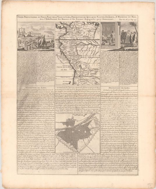
“Carte Particuliere du Perou, Plan de la Ville de Lima, Description de Quelques Plantes, Animaux, & Machines du Pays...”
Map Maker:
Henry Abraham Chatelain
This interesting folio sheet contains two maps and... (full text available to subscribers)
| Item Detail |
| |
| |
MapMaker: |
Henry Abraham Chatelain
|
|
| |
| |
Subject: |
Western South America, Peru |
|
| |
Period/Size: |
1720 / 19.6" x 14.8" (49.8 x 37.6 cm)
|
|
| |
Color: |
Black & White
|
|
| |
Condition: |
(A) A dark impression with some printer's ink residue in text at left and minor toning and foxing along the edges of the sheet.. (condition help) |
|
| |
Source: |
Atlas Historique |
|
| |
References: |
|
|
| |
|
|
| Sales Information |
| |
| |
Price: |
|
|
| |
| |
Offered by: |
Old World Auctions |
|
| |
Catalog: |
Auction No. 193 - Antique Maps, Charts, Atlases & Globes (9567) |
|
| |
Lot/Item #: |
371 |
|
| |
| |
Date: |
07/2023
|
|
| |
| |
|
Antique Maps - Valuation and Pricing, Descriptions, Resources |
|
Home |
Information |
Search |
Register |
Contact Us |
Site Map
Americana Exchange, Inc. © 1999 - 2024 Americana Exchange, Inc.. All rights reserved.
OldMaps.com, the OldMaps.com logo and
AMPR are service marks or registered service marks of Americana Exchange, Inc..
|