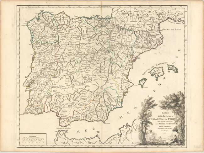
Title:
“Carte des Royaumes d'Espagne et de Portugal dans Laquelle sont Tracees les Routes des Postes”
Map Maker:
Gilles Robert de Vaugondy
This large, finely engraved map details the postal... (full text available to subscribers)
| Item Detail |
| |
| |
MapMaker: |
Gilles Robert de Vaugondy
|
|
| |
| |
Subject: |
Spain & Portugal |
|
| |
Period/Size: |
1757 / 18.8" x 22.4" (47.8 x 56.9 cm)
|
|
| |
Color: |
Colored
|
|
| |
Condition: |
(B+) A dark impression with contemporary outline color on a bright sheet with a small medallion watermark, a stain along the centerfold at top, and minor offsetting. (condition help) |
|
| |
Source: |
Atlas Universel |
|
| |
References: |
Pedley #303. |
|
| |
|
|
| Sales Information |
| |
| |
Price: |
|
|
| |
| |
Offered by: |
Old World Auctions |
|
| |
Catalog: |
Auction No. 193 - Antique Maps, Charts, Atlases & Globes (9567) |
|
| |
Lot/Item #: |
494 |
|
| |
| |
Date: |
07/2023
|
|
| |
| |
|
Antique Maps - Valuation and Pricing, Descriptions, Resources |
|
Home |
Information |
Search |
Register |
Contact Us |
Site Map
Americana Exchange, Inc. © 1999 - 2024 Americana Exchange, Inc.. All rights reserved.
OldMaps.com, the OldMaps.com logo and
AMPR are service marks or registered service marks of Americana Exchange, Inc..
|