Title:
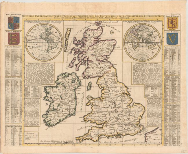
“Nouvelle Carte d'Angleterre, d'Ecosse et d'Irlande, avec des Instructions pour Connoitre les Differents Etats de la Couronne d'Angleterre en Europe, Asie, Afrique, et Amerique”
Map Maker:
Henry Abraham Chatelain
This unusual map of the British Isles includes two... (full text available to subscribers)
| Item Detail |
| |
| |
MapMaker: |
Henry Abraham Chatelain
|
|
| |
| |
Subject: |
Britain, World |
|
| |
Period/Size: |
1720 / 18.5" x 24.5" (47.0 x 62.3 cm)
|
|
| |
Color: |
Colored
|
|
| |
Condition: |
(A) A crisp impression, issued folding with minor offsetting and a hint of toning. (condition help) |
|
| |
Source: |
Atlas Historique |
|
| |
References: |
Shirley (BI to 1750) Chatelain 2. |
|
| |
|
|
| Sales Information |
| |
| |
Price: |
|
|
| |
| |
Offered by: |
Old World Auctions |
|
| |
Catalog: |
Auction No. 193 - Antique Maps, Charts, Atlases & Globes (9567) |
|
| |
Lot/Item #: |
404 |
|
| |
| |
Date: |
07/2023
|
|
| |
| |
|
Antique Maps - Valuation and Pricing, Descriptions, Resources |
|
Home |
Information |
Search |
Register |
Contact Us |
Site Map
Americana Exchange, Inc. © 1999 - 2024 Americana Exchange, Inc.. All rights reserved.
OldMaps.com, the OldMaps.com logo and
AMPR are service marks or registered service marks of Americana Exchange, Inc..
|