Title:
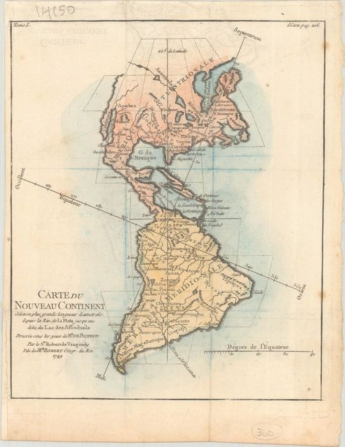
“Carte du Nouveau Continent Selon sa Plus Grande Longueur Diametrale Depuis la Riv. de la Plata Jusqu'au dela du Lac des Assiniboils...”
Map Maker:
Didier Robert de Vaugondy
This uncommon and interesting map shows the north-... (full text available to subscribers)
| Item Detail |
| |
| |
MapMaker: |
Didier Robert de Vaugondy
|
|
| |
| |
Subject: |
Western Hemisphere - America |
|
| |
Period/Size: |
1749 / 8.4" x 6.9" (21.4 x 17.6 cm)
|
|
| |
Color: |
Colored
|
|
| |
Condition: |
(B+) Issued folding with light offsetting and a few spots of foxing in map image. Remnants of hinge tape on verso. (condition help) |
|
| |
Source: |
Histoire Naturelle |
|
| |
References: |
Pedley #18. |
|
| |
|
|
| Sales Information |
| |
| |
Price: |
|
|
| |
| |
Offered by: |
Old World Auctions |
|
| |
Catalog: |
Auction No. 193 - Antique Maps, Charts, Atlases & Globes (9567) |
|
| |
Lot/Item #: |
73 |
|
| |
| |
Date: |
07/2023
|
|
| |
| |
|
Antique Maps - Valuation and Pricing, Descriptions, Resources |
|
Home |
Information |
Search |
Register |
Contact Us |
Site Map
Americana Exchange, Inc. © 1999 - 2024 Americana Exchange, Inc.. All rights reserved.
OldMaps.com, the OldMaps.com logo and
AMPR are service marks or registered service marks of Americana Exchange, Inc..
|